Liste der Kategorie-A-Bauwerke in Perth and Kinross
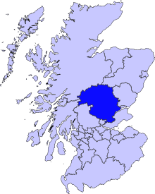
Die Liste der Kategorie-A-Gebäude in Perth and Kinross umfasst sämtliche in der Kategorie A eingetragenen Baudenkmäler in der schottischen Council Area Perth and Kinross. Die Einstufung wird anhand der Kriterien von Historic Scotland vorgenommen, wobei in die höchste Kategorie A Bauwerke von nationaler oder internationaler Bedeutung einsortiert sind. In Perth and Kinross sind derzeit 158 Bauwerke in der Kategorie A gelistet.
| Name | Lage | Typ | Eintrag | Bild |
|---|---|---|---|---|
| Bridge of Ruim | nahe Alyth 56° 37′ 47,5″ N, 3° 11′ 32,1″ W56.629861111111-3.19225 | Brücke | 53 | |
| Old Fincastle House | nahe Blair Atholl 56° 44′ 14,7″ N, 3° 51′ 8,3″ W56.737416666667-3.8523055555556 | Herrenhaus | 69 | |
| Sonnenuhr Nr. 2 von Stobhall | nahe Stanley 56° 29′ 39,7″ N, 3° 24′ 38″ W56.494361111111-3.4105555555556 | Sonnenuhr | 79 | |
| Drummonie House | nahe Bridge of Earn 56° 20′ 16,4″ N, 3° 25′ 46,5″ W56.337888888889-3.4295833333333 | Villa | 163 |  |
| Balhary House | nahe Alyth 56° 36′ 19,8″ N, 3° 11′ 56,9″ W56.6055-3.1991388888889 | Villa | 4379 | |
| Bridge of Isla | nahe Meikleour 56° 31′ 40,9″ N, 3° 21′ 41,1″ W56.528027777778-3.3614166666667 | Brücke | 4424 |  |
| Gourdie House | nahe Spittalfield 56° 33′ 52,5″ N, 3° 25′ 46,1″ W56.564583333333-3.4294722222222 | Villa | 4440 | |
| Meikleour Cross | Meikleour 56° 32′ 24,6″ N, 3° 22′ 17,9″ W56.540166666667-3.3716388888889 | Marktkreuz | 4446 |  |
| Bell Mill | Stanley 56° 28′ 45,1″ N, 3° 26′ 27,3″ W56.479194444444-3.4409166666667 | Mühle | 4486 |  |
| Mid Mill | Stanley 56° 28′ 44,3″ N, 3° 26′ 25,1″ W56.478972222222-3.4403055555556 | Mühle | 4489 | |
| Kilgraston House | Bridge of Earn 56° 20′ 30″ N, 3° 24′ 58,6″ W56.341666666667-3.4162777777778 | Herrenhaus | 4527 | 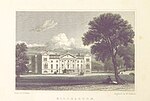 |
| Aberuchill Castle | nahe Comrie 56° 21′ 57,7″ N, 4° 1′ 59,4″ W56.366027777778-4.0331666666667 | Tower House | 5296 | 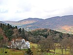 |
| Comrie Old Parish Church | Comrie 56° 22′ 25,9″ N, 3° 59′ 18,4″ W56.373861111111-3.9884444444444 | Kirche | 5385 |  |
| 1 Dunira Street | Comrie 56° 22′ 27,4″ N, 3° 59′ 17,1″ W56.374277777778-3.9880833333333 | Geschäftsgebäude | 5393 |  |
| Balmanno Castle | nahe Bridge of Earn 56° 19′ 29,2″ N, 3° 23′ 10,9″ W56.324777777778-3.3863611111111 | Tower House | 5422 | 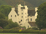 |
| Ecclesiamagirdle House | nahe Bridge of Earn 56° 19′ 53,4″ N, 3° 26′ 41,8″ W56.3315-3.4449444444444 | Herrenhaus | 5427 | |
| Taubenhaus von Ecclesiamagirdle House | nahe Bridge of Earn 56° 19′ 53,4″ N, 3° 26′ 40,5″ W56.3315-3.4445833333333 | Taubenhaus | 5430 | |
| Stobhall | nahe Stanley 56° 29′ 35,7″ N, 3° 24′ 41″ W56.49325-3.4113888888889 | Tower House | 5473 | 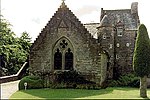 |
| Brauerei und Bäckerei von Stobhall | nahe Stanley 56° 29′ 36,3″ N, 3° 24′ 41,6″ W56.493416666667-3.4115555555556 | Wirtschaftsgebäude | 5474 | |
| Witwenhaus von Stobhall | nahe Stanley 56° 29′ 36,3″ N, 3° 24′ 40,4″ W56.493416666667-3.4112222222222 | Wohngebäude | 5475 | |
| Neue Bibliothek von Stobhall | nahe Stanley 56° 29′ 35,2″ N, 3° 24′ 41,5″ W56.493111111111-3.4115277777778 | Bibliothek | 5477 | |
| Sonnenuhr Nr. 1 von Stobhall | nahe Stanley 56° 29′ 37,3″ N, 3° 24′ 40,3″ W56.493694444444-3.4111944444444 | Sonnenuhr | 5479 | |
| Dunkeld Bridge | Dunkeld 56° 33′ 50,2″ N, 3° 35′ 6,9″ W56.563944444444-3.58525 | Brücke | 5620 |  |
| Dunkeld Cathedral | Dunkeld 56° 33′ 54,2″ N, 3° 35′ 23,7″ W56.565055555556-3.5899166666667 | Kirche | 5631 | 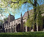 |
| Blackcraig Bridge | nahe Bridge of Cally 56° 39′ 56,5″ N, 3° 27′ 23,1″ W56.665694444444-3.4564166666667 | Brücke | 5674 |  |
| Ardblair Castle | nahe Blairgowrie and Rattray 56° 35′ 6,7″ N, 3° 21′ 48″ W56.585194444444-3.3633333333333 | Tower House | 5677 | |
| Cleish Castle | nahe Kinross 56° 9′ 56,1″ N, 3° 28′ 45″ W56.165583333333-3.4791666666667 | Tower House | 5711 |  |
| Blair Adam | nahe Kelty 56° 8′ 45,5″ N, 3° 24′ 10,5″ W56.145972222222-3.4029166666667 | Villa | 5715 | |
| Camserney Longhouse | nahe Aberfeldy 56° 37′ 12,3″ N, 3° 55′ 47″ W56.620083333333-3.9297222222222 | Bauernhaus | 5732 | |
| Tummel Bridge | nahe Loch Tummel 56° 42′ 28,3″ N, 4° 1′ 23,5″ W56.707861111111-4.0231944444444 | Brücke | 5742 |  |
| Monzie Castle | nahe Crieff 56° 23′ 57,2″ N, 3° 49′ 34,2″ W56.399222222222-3.8261666666667 | Herrenhaus | 5779 |  |
| Innerpeffray Library | nahe Crieff 56° 20′ 40,7″ N, 3° 46′ 41,8″ W56.344638888889-3.7782777777778 | Bibliothek | 5792 |  |
| Montrose Mausoleum | Aberuthven 56° 19′ 1,6″ N, 3° 39′ 40,3″ W56.317111111111-3.6611944444444 | Mausoleum | 5819 |  |
| Keltie Castle | nahe Dunning 56° 18′ 5,3″ N, 3° 36′ 19″ W56.301472222222-3.6052777777778 | Herrenhaus | 5912 | |
| Taubenhaus von Duncrub House | nahe Dunning 56° 19′ 0,7″ N, 3° 35′ 39,2″ W56.316861111111-3.5942222222222 | Taubenhaus | 5915 | |
| Auchleeks House | nahe Blair Atholl 56° 45′ 22,3″ N, 4° 3′ 37,4″ W56.756194444444-4.0603888888889 | Herrenhaus | 6054 | |
| Front Lodge von Blair Castle | Blair Atholl 56° 46′ 1″ N, 3° 50′ 45,1″ W56.766944444444-3.8458611111111 | Wohngebäude | 6064 | 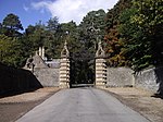 |
| Grotte am Tilt | Blair Atholl 56° 46′ 29″ N, 3° 50′ 29,3″ W56.774722222222-3.8414722222222 | Grotte | 6065 | |
| Blair Castle | nahe Blair Atholl 56° 46′ 24,1″ N, 3° 51′ 26,8″ W56.773361111111-3.8574444444444 | Burg | 6074 | 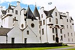 |
| Sonnenuhr von Blair Castle | nahe Blair Atholl 56° 46′ 23,8″ N, 3° 51′ 32,4″ W56.773277777778-3.859 | Sonnenuhr | 6076 | |
| Keithick House | nahe Burrelton 56° 31′ 55,4″ N, 3° 17′ 49,7″ W56.532055555556-3.2971388888889 | Herrenhaus | 6170 | |
| East Mill | Stanley 56° 28′ 44,6″ N, 3° 26′ 22,6″ W56.479055555556-3.4396111111111 | Mühle | 6690 | 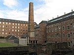 |
| Megginch Castle | nahe Errol 56° 24′ 27,1″ N, 3° 13′ 48″ W56.407527777778-3.23 | Burg | 10963 | |
| Stallungen von Megginch Castle | nahe Errol 56° 24′ 29″ N, 3° 13′ 50,5″ W56.408055555556-3.2306944444444 | Stallung | 10964 | 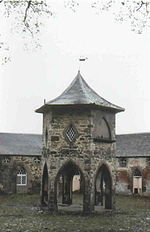 |
| North Lodge | nahe Errol 56° 24′ 37,5″ N, 3° 14′ 30,3″ W56.410416666667-3.24175 | Wohngebäude | 10969 | 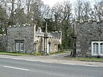 |
| Brücke von Balthayock House | nahe St Madoes 56° 23′ 35″ N, 3° 19′ 59,5″ W56.393055555556-3.3331944444444 | Brücke | 10986 | |
| Forteviot Square | Forteviot 56° 20′ 26,8″ N, 3° 32′ 7,8″ W56.340777777778-3.5355 | Wohngebäude | 11057 |  |
| Forteviot Hall | Forteviot 56° 20′ 24,9″ N, 3° 32′ 7,1″ W56.34025-3.5353055555556 | Halle | 11058 |  |
| Invermay House | nahe Forgandenny 56° 19′ 40,4″ N, 3° 31′ 14,2″ W56.327888888889-3.5206111111111 | Herrenhaus | 11071 | |
| Old House of Invermay | nahe Forgandenny 56° 19′ 43,9″ N, 3° 31′ 13,1″ W56.328861111111-3.5203055555556 | Tower House | 11074 | |
| Hermitage Bridge | nahe Birnam 56° 33′ 26″ N, 3° 36′ 51,9″ W56.557222222222-3.6144166666667 | Brücke | 11104 |  |
| Dalguise Viaduct | nahe Dunkeld 56° 36′ 46″ N, 3° 38′ 19,8″ W56.612777777778-3.6388333333333 | Brücke | 11117 |  |
| Bahnhof Dunkeld and Birnam | Birnam 56° 33′ 25,1″ N, 3° 34′ 41,9″ W56.556972222222-3.5783055555556 | Bahnhof | 11139 | 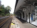 |
| Roman Bridge | nahe Murthly 56° 32′ 18″ N, 3° 32′ 5,9″ W56.538333333333-3.5349722222222 | Brücke | 11145 | |
| Murthly Castle | nahe Murthly 56° 32′ 29,7″ N, 3° 30′ 40,7″ W56.541583333333-3.5113055555556 | Herrenhaus | 11146 |  |
| Gärten von Murthly Castle | nahe Murthly 56° 32′ 27,7″ N, 3° 30′ 36,9″ W56.541027777778-3.51025 | Gärten | 11147 | |
| Kinross House | Kinross 56° 12′ 10,8″ N, 3° 24′ 35″ W56.203-3.4097222222222 | Herrenhaus | 11200 | 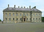 |
| Dalreoch Bridge | nahe Dunning 56° 20′ 34,4″ N, 3° 36′ 47,4″ W56.342888888889-3.6131666666667 | Brücke | 11211 |  |
| Kinnaird Castle | Kinnaird 56° 26′ 46,2″ N, 3° 13′ 56,8″ W56.446166666667-3.2324444444444 | Tower House | 11218 |  |
| Kirk O’ The Muir | nahe Murthly 56° 31′ 1,2″ N, 3° 26′ 39,9″ W56.517-3.4444166666667 | Kirchenruine | 11233 | |
| Hilton House | nahe Perth 56° 21′ 52,7″ N, 3° 25′ 54,8″ W56.364638888889-3.4318888888889 | Wohngebäude | 11329 | |
| Tullibole Castle | nahe Crook of Devon 56° 11′ 18,1″ N, 3° 31′ 40,8″ W56.188361111111-3.528 | Tower House | 11459 |  |
| Aldie Castle | nahe Crook of Devon 56° 9′ 47,6″ N, 3° 31′ 52,1″ W56.163222222222-3.5311388888889 | Tower House | 11469 | 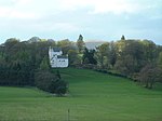 |
| Errol Parish Church | Errol 56° 23′ 34,7″ N, 3° 12′ 43,5″ W56.392972222222-3.2120833333333 | Kirche | 11589 | 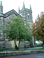 |
| Errol Park House | Errol 56° 23′ 23″ N, 3° 13′ 12,6″ W56.389722222222-3.2201666666667 | Villa | 11598 |  |
| Stallung von Errol Park House | Errol 56° 23′ 24,7″ N, 3° 13′ 14,1″ W56.390194444444-3.2205833333333 | Stallung | 11599 | |
| Seasyde House | nahe Errol 56° 24′ 22,7″ N, 3° 9′ 44,6″ W56.406305555556-3.1623888888889 | Villa | 11605 | |
| Ballindean House | nahe Inchture 56° 27′ 21″ N, 3° 11′ 18,2″ W56.455833333333-3.1883888888889 | Villa | 11760 | 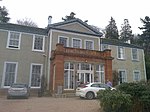 |
| Rossie Church | nahe Inchture 56° 27′ 50,6″ N, 3° 9′ 4,4″ W56.464055555556-3.1512222222222 | Kirche | 11786 | |
| Marktkreuz von Rossie | nahe Inchture 56° 27′ 48,2″ N, 3° 9′ 1,5″ W56.463388888889-3.1504166666667 | Marktkreuz | 11787 | |
| Grandtully Castle | nahe Grandtully 56° 38′ 26,4″ N, 3° 48′ 34,5″ W56.640666666667-3.8095833333333 | Tower House | 11830 |  |
| St Mary’s Church | nahe Grandtully 56° 38′ 3,4″ N, 3° 48′ 58,3″ W56.634277777778-3.8161944444444 | Kirche | 11831 |  |
| Logierait Viaduct | Logierait 56° 38′ 48,4″ N, 3° 41′ 0,2″ W56.646777777778-3.6833888888889 | Brücke | 11851 | 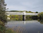 |
| Kinfauns Castle | nahe Perth 56° 23′ 18,2″ N, 3° 22′ 39,4″ W56.388388888889-3.3776111111111 | Burg | 11955 | 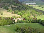 |
| Glendoick House | nahe St Madoes 56° 23′ 52,8″ N, 3° 17′ 7,2″ W56.398-3.2853333333333 | Herrenhaus | 11966 | 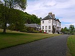 |
| Molkerei von Taymouth Castle | nahe Kenmore 56° 35′ 21,1″ N, 3° 59′ 18,7″ W56.589194444444-3.9885277777778 | Landwirtschaftliches Gebäude | 12091 | |
| Taymouth Castle | nahe Kenmore 56° 35′ 40,5″ N, 3° 58′ 52,8″ W56.594583333333-3.9813333333333 | Schloss | 12093 | 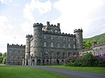 |
| Chinese Bridge | nahe Kenmore 56° 35′ 47,6″ N, 3° 59′ 4,9″ W56.596555555556-3.9846944444444 | Brücke | 12097 | 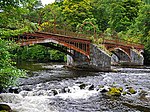 |
| Fort Lodge | nahe Kenmore 56° 35′ 28,1″ N, 3° 58′ 19,3″ W56.591138888889-3.9720277777778 | Wohngebäude | 12096 | |
| Rustic Lodge | nahe Kenmore 56° 35′ 25,3″ N, 3° 58′ 26,1″ W56.590361111111-3.9739166666667 | Wohngebäude | 12100 | |
| Kenmore Bridge | Kenmore 56° 35′ 8,5″ N, 4° 0′ 6,5″ W56.585694444444-4.0018055555556 | Brücke | 12138 | 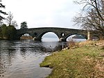 |
| Connachan Lodge | nahe Crieff 56° 25′ 39,1″ N, 3° 47′ 30,7″ W56.427527777778-3.7918611111111 | Wohngebäude | 12213 | |
| Sonnenuhr von Abercairny | nahe Crieff 56° 22′ 52,5″ N, 3° 45′ 53,9″ W56.38125-3.7649722222222 | Sonnenuhr | 12257 | |
| All Souls Episcopal Church | Invergowrie 56° 27′ 39,1″ N, 3° 3′ 46,2″ W56.460861111111-3.0628333333333 | Kirche | 12849 | 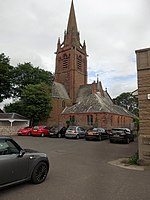 |
| Castle Huntly | Longforgan 56° 26′ 55,9″ N, 3° 8′ 1,9″ W56.448861111111-3.1338611111111 | Burg | 12868 | 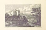 |
| Eishaus von Castle Huntly | Longforgan 56° 26′ 59,5″ N, 3° 8′ 2″ W56.449861111111-3.1338888888889 | Eishaus | 12870 | |
| North Gate | Longforgan 56° 27′ 11,7″ N, 3° 7′ 48,8″ W56.45325-3.1302222222222 | Tor | 12871 |  |
| Marktkreuz von Longforgan | Longforgan 56° 27′ 25,9″ N, 3° 7′ 11,8″ W56.457194444444-3.1199444444444 | Marktkreuz | 13283 | 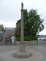 |
| Chapel of St Anthony the Eremite | nahe Murthly 56° 32′ 35,9″ N, 3° 30′ 42,6″ W56.543305555556-3.5118333333333 | Kirche | 13460 |  |
| Marlee House | Kinloch 56° 35′ 5,1″ N, 3° 23′ 13,6″ W56.58475-3.3871111111111 | Herrenhaus | 13742 | |
| Inchmartine House | nahe Inchture 56° 26′ 20,3″ N, 3° 11′ 52,4″ W56.438972222222-3.1978888888889 | Herrenhaus | 13773 |  |
| Maxwell’s Temple | nahe Kenmore 56° 35′ 22,9″ N, 3° 59′ 43,3″ W56.589694444444-3.9953611111111 | Folly | 13804 | |
| Meggernie Castle | nahe Loch Tay 56° 35′ 1,4″ N, 4° 21′ 22,7″ W56.583722222222-4.3563055555556 | Tower House | 13812 |  |
| Inchyra House | nahe St Madoes 56° 22′ 37,5″ N, 3° 18′ 45,5″ W56.377083333333-3.3126388888889 | Herrenhaus | 17624 | |
| Pitfour Castle | St Madoes 56° 22′ 24,3″ N, 3° 17′ 51,6″ W56.373416666667-3.2976666666667 | Herrenhaus | 17628 | 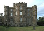 |
| Taubenturm von Elcho Castle | nahe Rhynd 56° 22′ 23,2″ N, 3° 21′ 22,6″ W56.373111111111-3.3562777777778 | Taubenturm | 17714 | 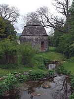 |
| Telefonzelle von Rhynd | Rhynd 56° 21′ 55″ N, 3° 21′ 51,9″ W56.365277777778-3.3644166666667 | Telefonzelle | 17718 |  |
| Colquhalzie House | nahe Muthill 56° 20′ 13,3″ N, 3° 45′ 31,4″ W56.337027777778-3.7587222222222 | Herrenhaus | 17771 | |
| Weem Old Parish Kirk | Weem 56° 37′ 32,2″ N, 3° 53′ 14,9″ W56.625611111111-3.8874722222222 | Kirche | 17815 |  |
| Williamston House | nahe Methven 56° 22′ 46,5″ N, 3° 39′ 57,2″ W56.379583333333-3.6658888888889 | Herrenhaus | 17836 | |
| Glenalmond College | nahe Methven 56° 26′ 30,9″ N, 3° 39′ 36,5″ W56.441916666667-3.6601388888889 | Schule | 17869 |  |
| Methven Castle | nahe Methven 56° 25′ 0,5″ N, 3° 33′ 17,5″ W56.416805555556-3.5548611111111 | Burg | 17895 | 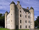 |
| Dalcrue House | nahe Methven 56° 26′ 1,5″ N, 3° 33′ 12,3″ W56.43375-3.5534166666667 | Villa | 17897 | |
| Dry Bridge | nahe Methven 56° 26′ 15,8″ N, 3° 32′ 13,1″ W56.437722222222-3.5369722222222 | Brücke | 17921 |  |
| Methven Aisle | Methven 56° 24′ 58,9″ N, 3° 34′ 51,7″ W56.416361111111-3.5810277777778 | Kirchenrest | 17928 |  |
| Lochlane House | nahe Crieff 56° 22′ 12,2″ N, 3° 53′ 20,5″ W56.370055555556-3.8890277777778 | Herrenhaus | 18149 | |
| Lawers House | nahe Comrie 56° 23′ 3,3″ N, 3° 56′ 46,4″ W56.38425-3.9462222222222 | Herrenhaus | 18152 |  |
| Ochtertyre House | nahe Crieff 56° 23′ 26,1″ N, 3° 52′ 57,4″ W56.390583333333-3.8826111111111 | Herrenhaus | 18170 | 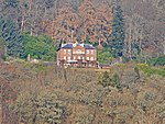 |
| Belmont Castle | Meigle 56° 34′ 54,1″ N, 3° 9′ 50″ W56.581694444444-3.1638888888889 | Herrenhaus | 18332 | |
| Scone Palace | nahe Scone 56° 25′ 22,2″ N, 3° 26′ 18,1″ W56.422833333333-3.4383611111111 | Schloss | 18370 | 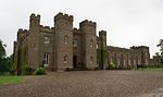 |
| Mausoleum von Scone Palace | nahe Scone 56° 25′ 24,9″ N, 3° 26′ 15,6″ W56.423583333333-3.4376666666667 | Mausoleum | 18371 |  |
| Cottown School | Cottown 56° 22′ 29,2″ N, 3° 17′ 15,1″ W56.374777777778-3.2875277777778 | Schule | 19809 | |
| Haugh of Drimmie Bridge | nahe Bridge of Cally 56° 38′ 11″ N, 3° 21′ 16,7″ W56.636388888889-3.3546388888889 | Brücke | 19830 | |
| Old Cross of Scone | nahe Scone 56° 25′ 25,6″ N, 3° 26′ 6,3″ W56.423777777778-3.4350833333333 | Marktkreuz | 19876 | 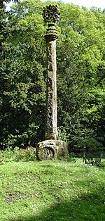 |
| Gärten von Drummond Castle | nahe Muthill 56° 20′ 22,3″ N, 3° 52′ 15″ W56.339527777778-3.8708333333333 | Gärten | 19883 | 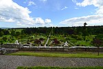 |
| Aberfeldy Water Mill | Aberfeldy 56° 37′ 9,9″ N, 3° 52′ 1,9″ W56.619416666667-3.8671944444444 | Mühle | 20859 |  |
| General Wade’s Bridge | Aberfeldy 56° 37′ 16,9″ N, 3° 52′ 24,9″ W56.621361111111-3.8735833333333 | Brücke | 20861 |  |
| Newton Castle | Blairgowrie and Rattray 56° 35′ 31,3″ N, 3° 21′ 1,5″ W56.592027777778-3.3504166666667 | Tower House | 22314 | 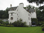 |
| Kriegsdenkmal von Blairgowrie | Blairgowrie and Rattray 56° 35′ 30,2″ N, 3° 20′ 13,3″ W56.591722222222-3.3370277777778 | Denkmal | 22321 |  |
| Keathbank Mill | Blairgowrie and Rattray 56° 36′ 0,1″ N, 3° 20′ 26,9″ W56.600027777778-3.3408055555556 | Mühle | 22332 |  |
| Inchglas | Crieff 56° 22′ 12,5″ N, 3° 50′ 19,1″ W56.370138888889-3.8386388888889 | Villa | 23488 | |
| British Linen Bank | Crieff 56° 22′ 22″ N, 3° 50′ 22,3″ W56.372777777778-3.8395277777778 | Wohn- und Geschäftsgebäude | 23489 |  |
| South United Free Church | Crieff 56° 22′ 28″ N, 3° 50′ 35,9″ W56.374444444444-3.8433055555556 | Kirche | 23509 | 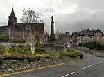 |
| St John’s Church | Perth 56° 23′ 44,8″ N, 3° 25′ 41,1″ W56.395777777778-3.4280833333333 | Kirche | 39300 |  |
| St Leonard’s-in-the-Fields | Perth 56° 23′ 32,2″ N, 3° 25′ 57,8″ W56.392277777778-3.4327222222222 | Kirche | 39310 |  |
| St Ninian’s Cathedral | Perth 56° 23′ 56,8″ N, 3° 26′ 7,5″ W56.399111111111-3.4354166666667 | Kirche | 39314 |  |
| King James VI Hospital | Perth 56° 23′ 41,1″ N, 3° 26′ 6,2″ W56.39475-3.4350555555556 | Krankenhaus | 39319 |  |
| Murray Royal Hospital | Perth 56° 24′ 1,3″ N, 3° 24′ 43,7″ W56.400361111111-3.4121388888889 | Krankenhaus | 39321 | |
| Old Perth Academy | Perth 56° 24′ 0,5″ N, 3° 25′ 56,7″ W56.400138888889-3.4324166666667 | Schule | 39322 | 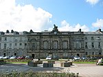 |
| AK Bell Library | Perth 56° 23′ 42,1″ N, 3° 26′ 15,1″ W56.395027777778-3.4375277777778 | Bibliothek | 39323 |  |
| Perth Sheriff Court | Perth 56° 23′ 40,6″ N, 3° 25′ 33,8″ W56.394611111111-3.4260555555556 | Gerichtsgebäude | 39325 |  |
| Wärterhaus des HM Prisons Perth | Perth 56° 23′ 8,9″ N, 3° 25′ 54,2″ W56.385805555556-3.4317222222222 | Gefängnis | 39326 | 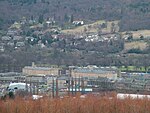 |
| Aultbea House | Perth 56° 23′ 9,3″ N, 3° 25′ 54,2″ W56.385916666667-3.4317222222222 | Gefängnis | 39328 | |
| Haupttrakt des HM Prisons Perth | Perth 56° 23′ 8″ N, 3° 25′ 48,5″ W56.385555555556-3.4301388888889 | Gefängnis | 39331 | |
| Greyfriars-Friedhof | Perth 56° 23′ 36,2″ N, 3° 25′ 37,9″ W56.393388888889-3.4271944444444 | Friedhof | 39338 |  |
| Perth Bridge | Perth 56° 23′ 56,4″ N, 3° 25′ 30,7″ W56.399-3.4251944444444 | Brücke | 39339 |  |
| Perth Water Works Building | Perth 56° 23′ 31,7″ N, 3° 25′ 34,9″ W56.392138888889-3.4263611111111 | Industriegebäude | 39341 | 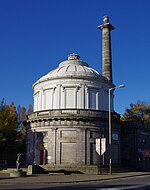 |
| Pitheavlis Castle | Perth 56° 23′ 20,3″ N, 3° 27′ 3″ W56.388972222222-3.4508333333333 | Tower House | 39346 |  |
| 2–8 Atholl Crescent | Perth 56° 23′ 57″ N, 3° 25′ 52,8″ W56.399166666667-3.4313333333333 | Wohngebäude | 39354 |  |
| 2–4 Charlotte Place | Perth 56° 23′ 55″ N, 3° 25′ 43,3″ W56.398611111111-3.4286944444444 | Wohn- und Geschäftsgebäude | 39392 | |
| Barnhill Tollhouse | Perth 56° 22′ 56,8″ N, 3° 24′ 49″ W56.382444444444-3.4136111111111 | Zollhaus | 39422 | |
| Upper City Mills | Perth 56° 23′ 50,6″ N, 3° 26′ 10,4″ W56.397388888889-3.4362222222222 | Mühle | 39577 |  |
| Lower City Mills | Perth 56° 23′ 50,6″ N, 3° 26′ 7,9″ W56.397388888889-3.4355277777778 | Mühle | 39578 | 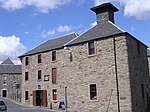 |
| Bank of Scotland | Perth 56° 23′ 44,5″ N, 3° 25′ 38,1″ W56.395694444444-3.42725 | Geschäftsgebäude | 39618 |  |
| Pitlochry Parish Church | Pitlochry 56° 42′ 14,9″ N, 3° 43′ 57,8″ W56.704138888889-3.7327222222222 | Kirche | 39850 |  |
| Sunnybrae Cottage | Pitlochry 56° 42′ 15,4″ N, 3° 44′ 19,2″ W56.704277777778-3.7386666666667 | Wohngebäude | 39866 |  |
| Bahnhof Pitlochry | Pitlochry 56° 42′ 8,5″ N, 3° 44′ 8,6″ W56.702361111111-3.7357222222222 | Bahnhof | 39867 | 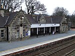 |
| Castle Menzies | nahe Aberfeldy 56° 37′ 26,1″ N, 3° 53′ 49,6″ W56.623916666667-3.8971111111111 | Tower House | 43568 | 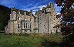 |
| Folly von Stobhall | nahe Stanley 56° 29′ 40,8″ N, 3° 24′ 38,5″ W56.494666666667-3.4106944444444 | Folly | 43856 | |
| Wasserkraftwerk Pitlochry | Pitlochry 56° 41′ 57″ N, 3° 44′ 25,4″ W56.699166666667-3.7403888888889 | Kraftwerk | 47534 |  |
| Baracken 19–20 und 44–46 des Cultybraggan Camps | nahe Comrie 56° 21′ 22,1″ N, 3° 59′ 38,9″ W56.356138888889-3.9941388888889 | Militäranlage | 50471 | 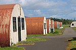 |
| Hallyburton House | nahe Kettins 56° 32′ 1″ N, 3° 13′ 28,6″ W56.533611111111-3.2246111111111 | Herrenhaus | 51605 | |
| Sonnenuhr von Hallyburton House | nahe Kettins 56° 32′ 0,4″ N, 3° 13′ 27,3″ W56.533444444444-3.22425 | Sonnenuhr | 51607 | |
| Wasserkraftwerk Tummel | Loch Tummel 56° 42′ 22,9″ N, 4° 1′ 16,2″ W56.706361111111-4.0211666666667 | Kraftwerk | 51715 | 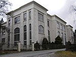 |
| Wasserkraftwerk Rannoch | Loch Rannoch 56° 41′ 34,7″ N, 4° 24′ 7″ W56.692972222222-4.4019444444444 | Kraftwerk | 51716 | 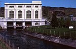 |
| Aviva UK Insurance Building | Perth 56° 23′ 0,9″ N, 3° 27′ 43,1″ W56.383583333333-3.4619722222222 | Geschäftsgebäude | 52450 |  |
| St Serf’s Church | Dunning 56° 18′ 45,6″ N, 3° 35′ 14,3″ W56.312666666667-3.5873055555556 | Kirche | 52454 | 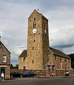 |
Weblinks
Commons: Kategorie-A-Bauwerke in Perth and Kinross – Sammlung von Bildern, Videos und Audiodateien
- Datenbank für Baudenkmäler von Historic Scotland
 Karte mit allen Koordinaten: OSM | WikiMap
Listen der Kategorie-A-Bauwerke in Schottland
Council areas:
Aberdeen | Aberdeenshire | Angus | Argyll and Bute | Äußere Hebriden | Clackmannanshire | Dumfries and Galloway | Dundee | East Ayrshire | East Dunbartonshire | East Lothian | East Renfrewshire | Edinburgh – Old Town – New Town | Falkirk | Fife | Glasgow | Highland | Inverclyde | Midlothian | Moray | North Ayrshire | North Lanarkshire | Orkney | Perth and Kinross | Renfrewshire | Scottish Borders | Shetland | South Ayrshire | South Lanarkshire | Stirling | West Dunbartonshire | West Lothian


