Saint-Honoré-les-Bains
| Saint-Honoré-les-Bains | ||
|---|---|---|
 |
| |
| Staat | Frankreich | |
| Region | Bourgogne-Franche-Comté | |
| Département (Nr.) | Nièvre (58) | |
| Arrondissement | Château-Chinon (Ville) | |
| Kanton | Luzy | |
| Gemeindeverband | Bazois Loire Morvan | |
| Koordinaten | 46° 54′ N, 3° 50′ O46.9066666666673.8411111111111Koordinaten: 46° 54′ N, 3° 50′ O | |
| Höhe | 222–555 m | |
| Fläche | 25,12 km² | |
| Einwohner | 691 (1. Januar 2021) | |
| Bevölkerungsdichte | 28 Einw./km² | |
| Postleitzahl | 58360 | |
| INSEE-Code | 58246 | |
 Blick von Osten auf Saint-Honoré-les-Bains | ||


Saint-Honoré-les-Bains ist eine französische Gemeinde mit 691 Einwohnern (Stand 1. Januar 2021) im Département Nièvre in der Region Bourgogne-Franche-Comté (vor 2016 Bourgogne). Sie gehört zum Arrondissement Château-Chinon (Ville) und zum Kanton Luzy. Die Einwohner werden Saint-Honoréens genannt.
Geographie
Saint-Honoré-les-Bains liegt etwa 55 Kilometer ostsüdöstlich von Nevers am Rande des Morvan. Umgeben wird Saint-Honoré-les-Bains von den Nachbargemeinden Préporché im Norden, Villapourçon im Nordosten und Osten, Sémelay im Süden sowie Vandenesse im Westen.
Bevölkerungsentwicklung
| Jahr | 1962 | 1968 | 1975 | 1982 | 1990 | 1999 | 2006 | 2011 | 2020 |
|---|---|---|---|---|---|---|---|---|---|
| Einwohner | 993 | 977 | 958 | 831 | 754 | 763 | 846 | 835 | 698 |
| Quellen: Cassini und INSEE | |||||||||
Sehenswürdigkeiten
- Kirche Saint-Loup aus dem 12. Jahrhundert
- Benediktiner-Priorat Saint-Honorat, 1106 gegründet
- Kapelle Sacre-Cœur, 1860 gebaut
- Thermen von Saint-Honoré-les-Bains
- Schloss La Montagne
- Herrenhaus von La Quedre
- Herrenhaus von Le Gué
- Widerstandsmuseum
-
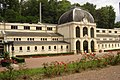 Thermen von Saint-Honoré-les-Bains
 -
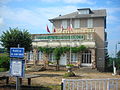 Widerstandsmuseum
 -
 Kapelle Sacre-Cœur


Literatur
- Le Patrimoine des Communes de la Nièvre. Flohic Editions, Band 2, Charenton-le-Pont 1999, ISBN 2-84234-054-X, S. 674–680.
Weblinks
Commons: Saint-Honoré-les-Bains – Sammlung von Bildern


