Allingawier
Village in Friesland, Netherlands

Flag

Coat of arms

Location in the former Wûnseradiel municipality
53°2′51″N 5°26′45″E / 53.04750°N 5.44583°E / 53.04750; 5.44583
 Netherlands
 Friesland
 Súdwest-Fryslân
 (2021)[1]
8758[1]
Allingawier is a small village in Súdwest-Fryslân municipality in the Dutch province of Friesland. It is about 7 km southwest of the city of Bolsward.
Allingawier is a terp village, on an artificial dwelling mound. It had a population of around 80 in January 2017.[3]
History
The village was first mentioned around 1275 as Alingwere, and means "settlement of the people of Ale (person)".[4] Allingawier was a terp (artificial living hill) village which was located on a ridge between lakes and pools. It was originally a fishing village.[5]
Allingawiere already had a church before 1000.[6] In 1634, the church was replaced by a chapel with a new tower. In 1839, after the Doleantie (schism in the Dutch Reformed Church), the Reformed community built a little church which now serves as visitor centre for the Aldfaers Erf Route.[5]
Allingawier was home to 114 people in 1840.[6] Between 1876 and 1879, the lakes Makkumermeer and Parregastermeer were poldered, and a canal was dug from Makkum to Tjerkwerd.[5]
In 1973, the Allinga State was built to resemble a 16th-century stins (manor house) with a tower with bells. It was in use as a bed and breakfast, but in 2021, it was for sale.[7] The estate was named after a 14th-century stins located a terp which was replaced in 1873 by a farm and a workman's house.[6]
Before 2011, the village was part of the Wûnseradiel municipality.[6]
Gallery
-
 Church of Allingawier
 -
 Former forge
 -
 Mansion Allingastate
 -
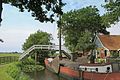 Canal view


References
- ^ a b c "Kerncijfers wijken en buurten 2021". Central Bureau of Statistics. Retrieved 5 April 2022.
- ^ "Postcodetool for 8758LB". Actueel Hoogtebestand Nederland (in Dutch). Het Waterschapshuis. Retrieved 5 April 2022.
- ^ Kerncijfers wijken en buurten 2017 - CBS Statline
- ^ "Allingawier - (geografische naam)". Etymologiebank (in Dutch). Retrieved 5 April 2022.
- ^ a b c "Allingawier". Friesland Wonderland (in Dutch). Retrieved 5 April 2022.
- ^ a b c d "Allingawier". Plaatsengids (in Dutch). Retrieved 5 April 2022.
- ^ "Nepkasteel Allingastate in Allingawier staat te koop, vraagprijs: 1,8 miljoen euro". Leeuwarder Courant (in Dutch). 27 July 2021. Retrieved 5 April 2022.
Wikimedia Commons has media related to Allingawier.
- v
- t
- e
Populated places in the municipality of Súdwest-Fryslân
- Abbegea
- Allingawier
- Arum
- Blauwhuis
- Boazum
- Breezanddijk
- Britswert
- Burgwerd
- Cornwerd
- Dearsum
- Dedgum
- Easterein
- Easterwierrum
- Exmorra
- Ferwoude
- Folsgare
- Gaast
- Gaastmeer
- Gauw
- Goënga
- Greonterp
- Hartwerd
- Heeg
- Hemelum
- Hichtum
- Hidaard
- Hieslum
- Hinnaard
- Hommerts
- Idsegahuizum
- Idzega
- Iens
- Indijk
- It Heidenskip
- Itens
- Jutrijp
- Kimswerd
- Kornwerderzand
- Koudum
- Koufurderrige
- Kûbaard
- Lollum
- Longerhouw
- Lytsewierrum
- Makkum
- Molkwerum
- Nijhuizum
- Nijland
- Oosthem
- Oppenhuizen
- Oudega
- Parrega
- Piaam
- Pingjum
- Poppenwier
- Reahûs
- Raerd
- Rien
- Sandfirden
- Scharl
- Scharnegoutum
- Schettens
- Schraard
- Sibrandabuorren
- Smallebrugge
- Tersoal
- Tirns
- Tjalhuizum
- Tjerkwerd
- Uitwellingerga
- Waaksens
- Warns
- Westhem
- Witmarsum
- Wiuwert
- Wolsum
- Wommels
- Wons
- Woudsend
- Ypecolsga
- Ysbrechtum
- Zurich
Authority control databases | |
|---|---|
| International |
|
| National |
|


