Scharl, Netherlands
Village in Friesland, Netherlands
Scharl Skarl | |
|---|---|
Village | |
 Scharl Bellfray | |
 Location in the former Nijefurd municipality | |
52°51′59″N 5°23′35″E / 52.8663°N 5.3930°E / 52.8663; 5.3930 | |
| Country |  Netherlands Netherlands |
| Province |  Friesland Friesland |
| Municipality |  Súdwest-Fryslân Súdwest-Fryslân |
| Area | |
| • Total | 6.16 km2 (2.38 sq mi) |
| Elevation | 0.4 m (1.3 ft) |
| Population (2021)[1] | |
| • Total | 60 |
| • Density | 9.7/km2 (25/sq mi) |
| Postal code | 8721[1] |
| Dialing code | 0514 |
Scharl is a small village in Súdwest-Fryslân municipality in the province of Friesland, the Netherlands. It had a population of around 55 in January 2017.[3]
History
The village was first mentioned in 1412 as Scarle. The etymology is unclear.[4] The village is located near the Roode Klif (Red Cliff), a nine metre high clay ridge, on the former Zuiderzee (nowadays: IJsselmeer) where the Battle of Warns took place in 1345 and William IV of Holland was defeated by Friesland.[5] Almost the entire army of Holland including count William were killed during the battle.[6]
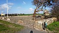
The church of the village has been demolished in 1732, and only a bell tower remains. The current bell tower dates from 1898.[5][6] Scharl was home to 48 people in 1840.[6] Before 2011, the village was part of the Nijefurd municipality and before 1984 it belonged to Hemelumer Oldeferd municipality.[6]
References
- ^ a b c "Kerncijfers wijken en buurten 2021". Central Bureau of Statistics. Retrieved 6 April 2022.
- ^ "Postcodetool for 8721EM". Actueel Hoogtebestand Nederland (in Dutch). Het Waterschapshuis. Retrieved 6 April 2022.
- ^ Kerncijfers wijken en buurten 2017 - CBS Statline
- ^ "Scharl - (geografische naam)". Etymologiebank (in Dutch). Retrieved 6 April 2022.
- ^ a b "Scharl". Friesland Wonderland (in Dutch). Retrieved 6 April 2022.
- ^ a b c d "Scharl". Plaatsengids (in Dutch). Retrieved 6 April 2022.
Gallery
-
 The Roode Klif
 -
 Monument celebrating the victory of Friesland over Holland


External links
![]() Media related to Scharl at Wikimedia Commons
Media related to Scharl at Wikimedia Commons
- v
- t
- e
Populated places in the municipality of Súdwest-Fryslân
- Bolsward
- Hindeloopen
- IJlst
- Sneek
- Stavoren
- Workum
- Abbegea
- Allingawier
- Arum
- Blauwhuis
- Boazum
- Breezanddijk
- Britswert
- Burgwerd
- Cornwerd
- Dearsum
- Dedgum
- Easterein
- Easterwierrum
- Exmorra
- Ferwoude
- Folsgare
- Gaast
- Gaastmeer
- Gauw
- Goënga
- Greonterp
- Hartwerd
- Heeg
- Hemelum
- Hichtum
- Hidaard
- Hieslum
- Hinnaard
- Hommerts
- Idsegahuizum
- Idzega
- Iens
- Indijk
- It Heidenskip
- Itens
- Jutrijp
- Kimswerd
- Kornwerderzand
- Koudum
- Koufurderrige
- Kûbaard
- Lollum
- Longerhouw
- Lytsewierrum
- Makkum
- Molkwerum
- Nijhuizum
- Nijland
- Oosthem
- Oppenhuizen
- Oudega
- Parrega
- Piaam
- Pingjum
- Poppenwier
- Reahûs
- Raerd
- Rien
- Sandfirden
- Scharl
- Scharnegoutum
- Schettens
- Schraard
- Sibrandabuorren
- Smallebrugge
- Tersoal
- Tirns
- Tjalhuizum
- Tjerkwerd
- Uitwellingerga
- Waaksens
- Warns
- Westhem
- Witmarsum
- Wiuwert
- Wolsum
- Wommels
- Wons
- Woudsend
- Ypecolsga
- Ysbrechtum
- Zurich
 | This Friesland location article is a stub. You can help Wikipedia by expanding it. |
- v
- t
- e


