Lake Wissota State Park

State park in Chippewa County, Wisconsin

44°58′12″N 91°17′52″W / 44.97000°N 91.29778°W / 44.97000; -91.29778Area1,062 acres (4.30 km2)Established1961Governing bodyWisconsin Department of Natural ResourcesWebsiteLake Wissota State Park

Lake Wissota State Park is a 1,062-acre (430 ha) Wisconsin state park near the town of Chippewa Falls. The park is situated on the northeast shore of Lake Wissota, a reservoir on the Chippewa River. Camping, boating, and fishing are the most popular activities. Park lands are covered in a mix of pine/hardwood forests and prairie. Visitors can access the Old Abe State Trail and bike or hike 17.5 miles (28.2 km) to Brunet Island State Park.

Geology

The bedrock beneath the park is two billion year old granite, which is overlain by 600 million year old Cambrian sandstone. An outcrop of this sandstone is visible south of the swimming beach. Otherwise these rock layers are blanketed by a thick layer of glacial sand and gravel. During the last ice age 15,000 years ago the Chippewa Lobe of the Wisconsin glaciation ended just six miles (10 km) northeast of the park. When the glaciers melted 10,000 years ago, rock debris settled in a 12-mile (19 km) wide outwash plain where the park is today. The prodigious meltwater also carved the valley of the Chippewa River.

History

A plaque detailing the history of the Wissota Hydroelectric Dam.

It has been estimated that the Chippewa River Valley once contained one-sixth of the United States' white pine stands. The entire valley was extensively logged for this target species from the mid-to-late 19th century. Once the harvest-able timber was gone, farmers began settling in the cleared out land.

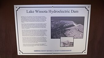
The Chippewa River was dammed for hydroelectric power in 1917, creating Lake Wissota.

As the sandy soil was marginal farmland, twelve landowners took advantage the federal Soil Bank Program between the mid-1950s and early 70s. This erosion-control program paid farmers to plant trees, and 205 acres (83 ha) here were planted with red pines. Today these trees still flank the park road near the campground.

Legislation authorizing the state park passed in 1961, championed by state senator Davis Donnelly. Wisconsin spent a decade acquiring 990 acres (400 ha) from various owners and developing services. The park formally opened to the public in 1972.

Flora and fauna

Lake Wissota State Park lies in the transition zone between prairie and temperate forest. The forest itself is a mix of hardwoods such as sugar maple and oak and softwoods such as red and white pine.

Greatly disrupted by decades of logging and farming, these vegetative communities are healthy again after extensive restoration ecology efforts. Controlled burning is conducted in the prairie. As a sustainable management model, the red pine stand is periodically thinned for maximum health. There are demonstration shoreline restoration projects near the swimming beach to educate homeowners about improving their lake frontage.

Two ducks out for a stroll on a frozen lake.
Sumac beginning to bloom with the lake in the background.
Looking up at several tall pine trees.

Recreation

The primary attraction of Lake Wissota State Park is its access to water recreation. The unguarded 285-foot (87 m) swimming beach, located on a quiet arm of the lake, is very popular on summer weekends. There is a two-lane launching ramp for power boats and fishing boats. Nearby is a canoe rental and a 25-foot (8 m) fishing pier specially built to be handicap-accessible. Game fish in Lake Wissota include walleye, muskies, bass, panfish, northern pike, catfish, and sturgeon. Fish cribs have been dropped into the lake to provide habitat for crappies and smallmouth bass. In winter visitors can go ice fishing for crappies, walleye, and bluegill.

The family campground contains 81 wooded sites, 17 with electrical hookups. At the south end of the park are two primitive, tent-only group campgrounds. One accommodates up to 100 people and the other up to 80 people.

There are 17.4 miles (28.0 km) of summer trails, most of which allow horses and mountain bikes. The Beaver Meadow Nature Trail is a shady, one mile (1.6 km) loop with interpretive signs which passes a wetland, a fern garden, natural springs, and an ancient river bed. In winter, there are 9.6 miles (15.4 km) of trail for snowshoeing, 7 miles (11 km) for cross-country skiing, and 5 miles (8 km) for snowmobiling.

The unstaffed Karen Lea Nature Center has tables of hands-on exhibits, and there are naturalist-led programs offered during summer weekends. The park also features two baseball diamonds and a volleyball court.

Gallery

A sign welcoming visitors to the park.
Steps leading down to the lake.
A view of the shoreline during summer.
A wooden bench overlooks the lake on a warm August day.
Boat launching arm of the lake.
Ducks and geese swimming near lakefront property.
Panoramic view of Lake Wissota from one of the scenic overlooks.

References

  • Bailey, Bill. Wisconsin State Parks. Glovebox Guidebooks of America: Saginaw, MI; 2000.
  • Wisconsin Department of Natural Resources. Lake Wissota State Park signage, brochures, and website.

External links

Wikimedia Commons has media related to Lake Wissota State Park.
  • Lake Wissota State Park Wisconsin Department of Natural Resources
  • v
  • t
  • e
Federal
National Park Service
National Forests
National Wildlife Refuges
National Trails
National Estuarine Research Reserves
National Marine Sanctuaries
National Wild and Scenic Rivers
  • St. Croix River
  • Wolf River
National Wilderness Preservation System
State
State Parks
State Natural Areas
  • Ableman's Gorge
  • Abraham's Woods
  • Adiantum Woods
  • Albany Sand Prairie & Oak Savanna
  • Allen Creek Wetlands
  • Allequash Lake
  • Alvin Creek Headwaters
  • Ancient Aztalan Village
  • Anvil Lake Trail
  • Apostle Islands Critical Species
  • Apostle Islands Maritime Cliffs
  • Apostle Islands Maritime Forest
  • Apostle Islands Sandscape
  • Apostle Islands Yew Forest
  • Apple River Canyon
  • Arbutus Oaks
  • Arena Pines and Sand Barrens
  • Argonne Experimental Forest
  • Atkins Lake & Hiles Swamp
  • Audubon Goose Pond
  • Aurora Lake
  • Avoca River-Bottom Prairie
  • Avon Bottoms
  • Badfish Creek Wet Prairie & Spring Seeps
  • Baileys Harbor Boreal Forest and Wetlands
  • Bakken's Pond
  • Baraboo River Floodplain Forest
  • Bark Bay Slough
  • Barksdale Ponds
  • Barneveld Prairie
  • Barney Creek
  • Bass Hollow
  • Bass Lake Fen
  • Bass Lake Peatlands
  • Bass Lake Preserve
  • Bastile Lake
  • Battle Bluff Prairie
  • Battle Creek Hemlocks
  • Bauer-Brockway Barrens
  • Baxter's Hollow
  • Bay City Mine
  • Bayshore Blufflands
  • Bean Lake
  • Bear Beach
  • Bear Bluff
  • Bear Caves
  • Bear Creek Cave
  • Bear Creek Hemlocks
  • Bear Creek Sedge Meadow
  • Bear Lake Sedge Meadow
  • Bear Lake Slough
  • Bearsdale Creek & Hyatt Springs
  • Beaver Brook
  • Beaver Creek
  • Belden Swamp
  • Belmont Mound
  • Belmont Prairie
  • Berg Prairie and Billy Goat Ridge
  • Bergen Bluffs
  • Berlin Fen
  • Beulah Bog
  • Bibon Swamp
  • Big and Little Marsh
  • Big Bay Sand Spit and Bog
  • Big Beaver Meadow
  • Big Eau Pleine Woods
  • Big Island
  • Big Manitou Falls
  • Big Rock Pines
  • Big Swamp
  • Big Swamp Tamarack Fen
  • Bittersweet Lakes
  • Black Creek Bog
  • Black Earth Rettenmund Prairie
  • Black Lake Bog
  • Black River Savanna
  • Black Tern Bog
  • Blackhawk Island
  • Blackjack Springs
  • Bloch Oxbow
  • Blomberg Lake
  • Blue Hills Felsenmeer
  • Blue River Bluffs
  • Blue River Sand Barrens
  • Blue Swamp
  • Blueberry Swamp
  • Blueberry Trail
  • Bluff Creek
  • Bogus Swamp
  • Bohn Lake
  • Bonita Country
  • Borah Creek Prairie
  • Border Lakes
  • Borst Valley Sedge Meadow
  • Boscobel Bluffs
  • Bradley Creek Swamp Conifers
  • Brady's Bluff Prairie
  • Brant Brook Pines
  • Brockway Ponds
  • Brooks Bluff
  • Browntown Oak Forest
  • Brule Glacial Spillway
  • Brule River Boreal Forest
  • Brule River Cliffs
  • Brule Rush Lake
  • Brunsweiler River and Mineral Lake
  • Brush Creek Hemlocks
  • Buckhorn Barrens
  • Buena Vista Prairie Chicken Meadow
  • Buena Vista Quarry Prairie
  • Buffalo River Trail Prairies
  • Butler Lake and Flynn's Spring
  • Cady's Marsh
  • Camp Five Lake
  • Camp Lake and Pines
  • Camp Nine Pines
  • Camp Three Lake
  • Canoe Landing Prairie
  • Caroline Lake
  • Carver-Roehl Woods
  • Caryville Savanna
  • Cassville Bluffs
  • Castle Mound Pine Forest
  • Catfish Eddy Terraces
  • Cathedral Pines
  • Catherine Lake Hemlock-Hardwoods
  • Cave Point-Clay Banks
  • Cedar Grove Hawk Research Station
  • Cedarburg Beech Woods
  • Cedarburg Bog
  • Centennial Bedrock Glade
  • Charles Pond
  • Chequamegon Hardwoods
  • Cherney Maribel Caves
  • Cherokee Marsh
  • Cherry Lake Sedge Meadow
  • Chimney Rock Oak Opening
  • Chippewa Moraine Lakes
  • Chippewa Trail
  • Chiwaukee Prairie
  • Chub and Mud Lake Riverine Marsh
  • Chub Lake Oak Savanna
  • Clifford Messinger Dry Prairie & Savanna Preserve
  • Clover Valley Fen
  • Coffee Swamp
  • Comstock Bog-Meadow
  • Coon Creek Cliffs
  • Coon Fork Barrens
  • Copper Falls
  • County Line Barrens and Forest
  • Cranberry Creek Mound Group
  • Crandon Ribbed Fen
  • Crex Sand Prairie
  • Crooked Lake Wetlands
  • Cudahy Woods
  • Cylon
  • Dalles of the St. Croix River
  • Day Lake
  • Deansville Fen
  • Deer Creek Tamarack Bog
  • Deer Fly Swamp
  • Deer Island
  • Deer Mountain
  • Dells of the Eau Claire River
  • Dells of the Wisconsin River
  • Detroit Harbor
  • Devil's Backbone
  • Devil's Lake Oak Forest
  • Devine Lake & Mishonagon Creek
  • Dewey Heights Prairie
  • Dewey Marsh
  • Diamond Lake
  • Diamond Roof
  • Doering Woods
  • Dorothy Lake
  • Dory's Bog and Hunt Hill
  • Drummond Woods
  • Dry Lake
  • Dunbar Barrens
  • Dunn Lake
  • Dunnville Barrens
  • Dupage Lake Peatlands
  • Durst Rockshelter
  • Dwight's Point and Pokegama Wetlands
  • Eagle Centre Prairie
  • Eagle Eye
  • Eagle Oak Opening
  • East Bluff
  • East Fork Chippewa River
  • East Fork of the Black River
  • Echo Lake
  • Eighteen Mile Creek
  • Ekdall Wetlands
  • Elk River Valley
  • Ellison Bluff
  • Emmons Creek Barrens
  • Empire Prairies
  • Empire Swamp
  • English Lake Hemlocks
  • Enterprise Hemlocks
  • Ericson Creek Forest and Wetlands
  • Eureka Maple Woods
  • Europe Bay Woods
  • Fair Meadows
  • Fairy Chasm
  • Fairyland
  • Farmington Bottoms
  • Faville Prairie
  • Fern Dell Gorge
  • Ferry Bluff
  • Finnerud Pine Forest
  • Fish Lake Meadow
  • Fish Lake Pines
  • Five Mile Barrens
  • Five-Mile Bluff Prairie
  • Flambeau River Hardwood Forest
  • Flambeau Wetlands
  • Flat Lake
  • Flora Spring Pond
  • Flume Creek Cedars
  • Forbes Springs
  • Fort McCoy
  • Foulds Creek
  • Fountain Creek Wet Prairie
  • Fourmile Island Rookery
  • Fox Maple Woods
  • Franklin and Butternut Lakes
  • Franklin Savanna
  • French Creek Fen
  • French Creek North
  • Frog Lake and Pines
  • Gasner Hollow Prairie
  • Genesse Oak Opening and Fen
  • Germain Hemlocks
  • Germania Wet Prairie
  • Ghost Lake
  • Giant White Pine Grove
  • Gibraltar Rock
  • Glenn Creek Barrens
  • Glocke Lake
  • Gobler Lake
  • Goose Lake
  • Goose Lake Drumlins
  • Gotham Jack Pine Barrens
  • Grand Island
  • Grandma Lake
  • Grassy Lake
  • Great River Trail Prairies
  • Hagar Mountain
  • Haley Creek Swamp
  • Half Moon Bottoms
  • Hanson Lake Wetlands
  • Hardscrabble Prairie
  • Haskell Noyes Memorial Woods
  • Hawkins Hemlock-Hardwood Forest
  • Hawkinson Creek Wet Prairie
  • Haymeadow Creek
  • Haymeadow Flowage
  • Headwater Lakes
  • Hedmark Pines
  • Hemlock Draw
  • High Cliff Escarpment
  • Highway K Woods
  • Hiles Wetlands
  • Hog Island Tamaracks
  • Hogback Prairie
  • Holland Red Maple Swamp
  • Holland Sand Prairie
  • Holmboe Conifer Forest
  • Honey Creek
  • Hook Lake Bog
  • Hortonville Bog
  • Houghton Falls
  • Hub City Bog
  • Huiras Lake
  • Hulburt Creek Woods
  • Hunting River Alders
  • Inch Lake
  • Interstate Lowland Forest
  • Ipswich Prairie
  • Island Lake Hemlocks
  • Jackson Creek Woods
  • Jackson Harbor Ridges
  • Jackson Marsh
  • Jay Creek Pine Forest
  • Jean Brunet Woods
  • Jefferson Tamarack Swamp
  • Johnson Falls
  • Johnson Hill Kame
  • Johnson Lake Barrens
  • Jones Lake
  • Jump River Woods
  • Jung Hemlock-Beech Forest
  • Kamrath Creek Forest and Fen
  • Kangaroo Lake
  • Karcher Springs
  • Karner Blue Meadow
  • Keller Whitcomb Creek Woods
  • Kelly Lake Hemlocks
  • Kelly Lynn Bog
  • Kentuck Lake
  • Kessler Railroad Prairie
  • Ketchum Creek Pines
  • Kettle Hole Woods
  • Kettle Moraine Low Prairie
  • Kettle Moraine Oak Opening
  • Kettle Moraine Red Oaks
  • Kewaskum Maple-Oak Woods
  • Kickapoo Valley Reserve
  • Kickapoo Wild Woods
  • Kidrick Swamp
  • Kieper Creek
  • Kingston Pines
  • Kinnickinnic River Gorge and Delta
  • Kinnickinnic Wet Prairie
  • Kirby Lake Hardwoods
  • Kissick Alkaline Bog Lake
  • Kohler Park Dunes
  • Kohler-Peet Barrens
  • Koro Prairie
  • Koshkonong Corners
  • Kroenke Lake
  • Krueger Pines
  • Kurtz Woods
  • La Crosse River Trail Prairie
  • LaFave Swamp
  • Lake Alva Birch-Hemlock
  • Lake Evelyn
  • Lake Helane
  • Lake Lackawanna
  • Lake Laura Hardwoods
  • Lake Noquebay Sedge Meadow
  • Lake of the Pines Conifer-Hardwoods
  • Lake Owen Hardwoods
  • Lake Two Pines
  • Lampson Moraine Pines
  • LaSage Bottoms
  • Lauterman Lake
  • Lawin Sedge Meadow
  • Lawrence Creek
  • Lawrence Lake
  • Lawrence Prairie
  • Lawrence Lake
  • Lemonweir Bottomland Hardwood Forest
  • Lily Lake
  • Lima Bog
  • Limery Ridge Savanna
  • Little Bear Hemlocks
  • Little Lake
  • Little Willow Drumlin
  • Little Wolf River
  • Lodde's Mill Bluff
  • Lodi Marsh
  • Logan Creek
  • Loon Lake Woods
  • Lost Canoe
  • Lost Creek Bog
  • Lost Lake
  • Lost Lake Esker
  • Lower Chippewa River
  • Lower Narrows
  • Lower Tomahawk River Pines
  • LTC Old Growth Forest
  • Lulu Lake
  • Lunch Creek Wetlands
  • Magnolia Bluff
  • Maiden Rock Bluff
  • Marinette County Beech Forest
  • Marsh Miller Cedars
  • Marshall's Point
  • Martin's Woods
  • Mary Lake
  • Mayville Ledge Beech-Maple Woods
  • Mazomanie Bottoms
  • Mazomanie Oak Barrens
  • McCarthy Lake and Cedars
  • McCaslin Mountain
  • McGilvra Woods
  • Mead Conifer Bogs
  • Meadow Valley Barrens
  • Mecan River Pine-Oak Forest
  • Mecan Springs
  • Memorial Grove Hemlocks
  • Meridian Park
  • Midway Railroad Prairie
  • Mill Bluff
  • Millston Sand Barrens
  • Millville Oak Woodlands
  • Milwaukee River and Swamp
  • Milwaukee River Floodplain Forest
  • Milwaukee River Tamarack Lowlands and Dundee Kame
  • Minito Lake
  • Mink River
  • Mirror Lake Pine Oak Forest
  • Miscauno Cedar Swamp
  • Mondeaux Hardwoods
  • Moonlight Bay Bedrock Beach
  • Moose Lake
  • Moose River Cedar Hills
  • Moquah Barrens
  • Morgan Coulee Prairie
  • Motts Ravine
  • Mount Pisgah Hemlock-Hardwoods
  • Mountain Lake
  • Mud Lake
  • Mud Lake - Radley Creek Savanna
  • Mud Lake Bog
  • Mud Lake Fen and Wet Prairie
  • Mud Lake Forest and Ponds
  • Muddy Creek Sedge Meadow
  • Muehl Springs
  • Muir Park
  • Mukwa Bottomland Forest
  • Mukwonago River
  • Mullet Creek White Cedar Wetland
  • Muralt Bluff Prairie
  • Muskego Park Hardwoods
  • Myklebust Lake
  • Namekagon Barrens
  • Namekagon Fen
  • Natural Bridge and Rockshelter
  • Navarino Cedar Swamp
  • Navarino Sedge Meadow
  • Necedah Oak-Pine Forest
  • Necedah Oak-Pine Savanna
  • Neda Mine
  • Nell Lake
  • Nelligan Lake
  • Nelson-Trevino Bottoms
  • Nemadji River Floodplain Forest
  • New Auburn Sedge Meadow
  • New Hope Pines
  • New Munster Bog Island
  • New Observatory Woods
  • Newark Road Prairie
  • Newport Conifer-Hardwoods
  • Nichols Creek Cedars and Springs
  • Nichols Creek East Cedars
  • Nine Mile Island
  • Nipissing Swamp
  • Nixon Lake
  • No Name Lake
  • North Bay
  • North Bend Wet Prairie
  • North Branch Bottoms
  • North Country Trail Hardwoods
  • North Fork Eau Claire River
  • North Fork Pines
  • North of North Shattuck Lake
  • North Otter Creek
  • North Pikes Creek Boreal Forest
  • North Pikes Creek Boreal Forest
  • Northeast Lake
  • Norway Point Bottomlands
  • Nourse Sugarbush
  • Oakfield Ledge
  • Oakfield Railroad Prairie
  • Observatory Hill
  • Ohmart Wetlands
  • Oliver Prairie
  • Olson Oak Woods
  • One Stone Lake Hemlocks
  • Orion Mussel Bed
  • Osceola Bedrock Glades
  • Oshkosh-Larsen Trail Prairies
  • Ottawa Lake Fen
  • Otter Creek Oak Barrens
  • Owl Creek Fen Savanna
  • Oxbo Pines
  • Oxbow Rapids
  • Page Creek Marsh
  • Pan Hollow
  • Papoose Creek Pines
  • Parfrey's Glen
  • Parrish Oak Savanna
  • Pat Shay Lake
  • Patterson Hemlocks
  • Pea Creek Sedge Meadow
  • Peat Lake
  • Pecatonica River Woods
  • Peninsula Niagara Escarpment
  • Peninsula Park Beech Forest
  • Peninsula Park White Cedar Forest
  • Perkinstown Hemlocks
  • Peshtigo Brook Meadow & Woods
  • Peshtigo Harbor Lacustrine Forest
  • Peshtigo River Delta Marshes
  • Pewit's Nest
  • Pickerel Lake
  • Pickerel Lake Fen
  • Pine Cliff
  • Pine Hollow
  • Pine Island Savanna
  • Pirus Road Swamp
  • Plagge Woods
  • Plainfield Tunnel Channel Lakes
  • Pleasant Valley Conservancy
  • Plover River Woods
  • Plum Creek Woods
  • Plum Lake Hemlock Forest
  • Point Beach Ridges
  • Pokegama Carnegie Wetlands
  • Pope Lake
  • Popple River Corridor
  • Poppy's Rock
  • Port Wing Boreal Forest
  • Portland Maples
  • Powers Bluff Maple Woods
  • Priest Rock
  • Princeton Prairie
  • Puchyan Prairie
  • Putnam Park
  • Quincy Bluff and Wetlands
  • Rainbow Wetlands
  • Rat Lake Swamp and Popple River Headwaters
  • Red Banks Alvar
  • Red Cedar Lake
  • Red Cedar River Savanna
  • Red Oak Bottoms
  • Reed Lake Meadow
  • Renak-Polak Maple Beech Woods
  • Rhine Center Bog
  • Rib Mountain Talus Forest
  • Rice Creek
  • Rice Lake
  • Richter Lake Hemlocks
  • Richwood Bottoms
  • Ridgeway Pine Relict
  • Riley Lake
  • Riveredge Creek and Ephemeral Pond
  • Robinson Creek Pines
  • Roche-A-Cri Mound
  • Roche-A-Cri Woods
  • Rock Creek Felsenmeer
  • Rock Island Woods
  • Rock Lake
  • Rock River Prairie
  • Rocky Run Oak Savanna
  • Romance Prairie
  • Rose Lake
  • Rush Creek
  • Rush Lake
  • Rush River Delta
  • Sajdak Springs
  • Sand Creek Pines
  • Sander's Park Hardwoods
  • Sapa Spruce Bog
  • Savage Lake
  • Schluckebier Prairie
  • Schmidt Maple Woods
  • Scott Lake and Shelp Lake
  • Scuppernong Prairie
  • Seagull Bar
  • Shaky Lake
  • Shallow Lake
  • Silver Creek and Mondeaux River
  • Silver Lake Bog
  • Sister Islands
  • Skinner Creek Hardwoods
  • Skunk and Foster Lakes
  • Skunk Creek Woods
  • Smith Drumlin Prairie
  • Smith Slough and Sand Prairie
  • Snake Creek Fen
  • Snapper Prairie
  • Snoose Creek
  • Snow Bottom
  • Snow Falls Creek
  • Sohlberg Silver Lake
  • Solon Springs Sharptail Barrens
  • South Bluff/Devil's Nose
  • South Branch Beech Grove
  • South Fork Barrens
  • Spaulding Fen
  • Spider Lake
  • Spread Eagle Barrens
  • Spring Brook Drumlins
  • Spring Green Preserve
  • Spring Lake
  • Springstead Muskeg
  • Springvale Wet Prairie
  • Spruce Grouse Swamp
  • Spruce Lake Bog
  • Spur Lake
  • Squirrel River Pines
  • St. Croix Ash Swamp
  • St. Croix Islands
  • St. Croix Seeps
  • St. Peter's Dome
  • Standing Cedars
  • Starlight Wetlands
  • Sterling Barrens
  • Stockbridge Ledge Woods
  • Stone Lake Pines
  • Straight Lake Tamarack Fen
  • Sugar Camp Hemlocks
  • Sugar Creek Bluff
  • Sugar River Wetlands
  • Suk Cerney Peatlands
  • Summerton Bog
  • Sunrise Lake
  • Swamp Creek Fen
  • Swamp Lake
  • Swan Lake Sedge Meadow and Barrens
  • Swan Lake Tamaracks
  • Swan Lake Wet-mesic Prairie
  • Swenson Wet Prairie
  • Tamarack Creek Bog
  • Tar Dam Pines
  • Tealey Creek Cedars
  • Tellock's Hill Woods
  • Texas Island Woods
  • The Ridges Sanctuary
  • Thornapple Hemlocks
  • Thorp Pond
  • Thunder Mountain
  • Thunder River Swamp
  • Tichigan Springs and Fen
  • Tiffany Bottoms
  • Toft Point
  • Tomahawk Lake Hemlocks
  • Totagatic Highlands Hemlocks
  • Totogan Pines
  • Tower Hill Bottoms
  • Town Corner Cedars
  • Town Line Lake and Woods
  • Toy Lake Swamp
  • Trade River Forest and Wetlands
  • Tranus Lake
  • Trempealeau Mountain
  • Trempealeau River Meadow
  • Trenton Bluff Prairie
  • Trout Lake Conifer Swamp
  • Trout River
  • Tucker Lake Hemlocks
  • Tula Lake
  • Tunnel Channel Woods
  • Tunnelville Cliffs
  • Turtle Flambeau Peatlands
  • Twin Lakes Bog
  • Two Creeks Buried Forest
  • Two Lakes Pine-Oak Forest
  • Upper Black River
  • Upper Brunet River
  • Upper Buckatabon Springs
  • Upper Fox Headwaters
  • Upper Kaubashine Creek
  • Upper Little Wolf
  • Upper Nemadji River Floodplain Forest
  • Upper Tomahawk River Pines
  • Van Loon Floodplain Forest
  • Van Loon Floodplain Savanna
  • Van Vliet Hemlocks
  • Vosse Coulee
  • Wabikon Lake
  • Ward/Swartz Decatur Woods
  • Warnimont Bluff Fens
  • Washburn Marsh
  • Waterloo Prairie
  • Waterloo Quartzite Outcrops
  • Waubesa Wetlands
  • Waupee Lake Swamp
  • Waupun Park Maple Forest
  • Wauzeka Bottoms
  • Wedde Creek Savanna
  • Weir White Oaks
  • Wheeler Lake
  • White Cliff Fen and Forest
  • White River Boreal Forest
  • White River Breaks
  • White River Prairie Tamarack
  • White River Sedge Meadow
  • Whitefish Dunes
  • Whitman Bottoms Floodplain Forest
  • Wildcat Ridge
  • Wilson Lake
  • Winchester Meadow
  • Wind Pudding
  • Wisconsin Slough
  • Wolf River Bottoms
  • Woodland Dunes
  • Woodman Lake Sand Prairie & Dead Lake
  • Woods Creek
  • Wyalusing Hardwood Forest
  • Wyalusing Walnut Forest
  • Yellow River Floodplain Forest
  • Yellow River Ice-walled Lake Plain
  • Yellow River Oxbows
  • Yellowstone Savanna
  • York Prairie
  • Young Prairie
State Recreation Areas
State Forests
State Historical Sites
State Wildlife Areas
  • Ackley
  • Adell
  • Albany
  • Allenton
  • Amberg
  • Amsterdam Sloughs
  • Augusta
  • Avon Bottoms
  • Badfish Creek
  • Balsam Branch
  • Barker Creek
  • Bear Lake
  • Beaver Brook
  • Bierbrauer
  • Big Beaver Creek
  • Big Muskego Lake
  • Big Swamp
  • Bill Cross
  • Blackhawk Lake
  • Bloomfield
  • Borst Valley
  • Brillion
  • Brooklyn
  • Brusky
  • Buckhorn
  • Buena Vista
  • Burlington
  • C.D. Besadny
  • Casey Lake
  • Chief River
  • Chimney Rock
  • Clam Lake
  • Clay Corners
  • Clover Valley
  • Colburn
  • Collins Marsh
  • Crex Meadows
  • Cylon Marsh
  • Cylon
  • Deansville
  • Deer Creek
  • Dell Creek
  • Deppe
  • Dewey Marsh
  • Dike 17
  • Douglas County
  • Dover
  • Dunnville
  • Eau Galle River
  • Eldorado
  • Emerald Valley
  • Evansville
  • Fish Lake
  • Flat Creek
  • Footville
  • French Creek
  • Galbraith
  • Gardner Swamp
  • Germania Marsh
  • Gilbert Creek
  • Goose Lake (Burnett County)
  • Goose Lake (Dane County)
  • Goose Pond
  • Grand River Marsh
  • Grassy Lake (Barron County)
  • Grassy Lake (Columbia County)
  • Green Bay West Shores
  • Greenwood
  • Hacker Drive
  • Hay Creek
  • Hay Creek-Hoffman Lake
  • Hay River
  • Highway 144
  • Highway T
  • Holland
  • Honey Creek Streambank
  • Honey Creek
  • Hook Lake Bog-Grass Lake
  • Hoosier Creek
  • Horicon Marsh
  • Jackson Marsh
  • Jaeger's Island
  • Jefferson Marsh
  • Jennings Creek
  • Joel Marsh
  • Johnson
  • Karcher
  • Kickapoo River Bell Center
  • Kickapoo River Wauzeka Unit
  • Kiel Marsh
  • Killsnake
  • Kimberly Clark
  • Kinnickinnic River Oscar Lee
  • Kinnickinnic River Potton
  • Kinnickinnic River Headwaters
  • Kinnickinnic River South Fork
  • Kissick Swamp
  • Knapp Creek
  • Koshkonong
  • Lake Mills
  • Lake Noquebay
  • Lake Pepin
  • Lakes Coulee
  • Lambs Creek
  • Lawrence Creek
  • Leola Marsh
  • Liberty Creek
  • Lightning Creek
  • Lima Marsh
  • Little Rice
  • Lodi Marsh
  • Loon Lake
  • Lundy Pond
  • Lyons
  • Mack
  • Maine
  • Manion
  • Mashek Creek
  • McAdams
  • McKenzie Creek
  • McMillan Marsh
  • Mead
  • Meadow Valley
  • Morgan Marsh
  • Mount Hope
  • Mud Lake (Columbia County)
  • Mud Lake (Dane County)
  • Mud Lake (Dodge County)
  • Muddy Creek
  • Mukwa
  • Mullet Creek
  • Nagel
  • Namekagon Barrens
  • Navarino
  • New Auburn
  • New Munster
  • New Wood
  • Nichols Creek
  • North Bend Bottoms
  • North Branch Milwaukee River
  • Oakridge
  • Oden
  • Omer Springs
  • Otter Creek
  • Outagamie
  • Paradise Marsh
  • Paradise Valley
  • Paul J. Olson
  • Pershing
  • Peshtigo Brook
  • Peter Helland
  • Peters Marsh
  • Pierce County Islands
  • Pine Island
  • Pleasant Valley
  • Potato Creek
  • Powell Marsh
  • Poygan Marsh
  • Prince's Point
  • Quaderer's Creek
  • Rat River
  • Ray
  • Ray Morrison Memorial
  • Rice Beds Creek
  • Ridgeville
  • Rock Falls
  • Rome Pond
  • Rush River
  • Sampson
  • Sandhill
  • Schmit
  • Scuppernong River
  • Sette
  • Shaw Marsh
  • Sheboygan Marsh
  • Silvernail
  • South Beaver Creek
  • Spring Creek
  • St. Croix Islands
  • Star Prairie Seed Farm
  • Storrs Lake
  • Straight Lake
  • Swan Lake
  • Sweeny Pond
  • Swinging Gate
  • Tamarack Creek
  • Ten Mile Creek (Rusk County)
  • Ten Mile Creek (Saint Croix County)
  • Theresa Marsh
  • Thunder Lake
  • Tichigan
  • Tiffany
  • Tollefson Marsh
  • Tom Lawin
  • Totagatic Lake
  • Totogatic
  • Town Corner
  • Troy
  • Turtle Creek
  • Turtle Valley
  • Ulrich
  • Underwood
  • Van Loon
  • Vermillion River
  • Vernon
  • Vosse Coulee
  • Washington Creek
  • Waterloo
  • Waunakee Marsh
  • Weirgor Springs
  • West Taylor
  • Whalen Creek
  • White River
  • White River Marsh
  • Whitman Dam
  • Willow River
  • Wind Lake
  • Wolf River Bottoms Herb Behnke
  • Wolf River Bottoms LaSage
  • Wolf River
  • Wood County
  • Woodboro Lakes
  • Yellow River
  • Yellowstone
Authority control databases: National Edit this at Wikidata
  • Israel
  • United States