Woltzeten
Village of Krummhörn in Lower Saxony, Germany

Coat of arms
Location of Woltzeten

- 04923
- 04927
Woltzeten is a village in the region of East Frisia, in Lower Saxony, Germany. It is part of the municipality of Krummhörn. The village consists of two built-up areas, Woltzeten in the west and Woltzetener Vorwerk in the east.
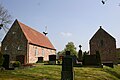
The village is located on a warft, three kilometers south of Pewsum and about eight kilometers northwest of the city of Emden. The current church of Woltzeten was built in 1727.[1] Before that there was a larger church, which had to be demolished in 1725 due to dilapidation. This predecessor church probably dates from the 12th century.
A Premonstratensian monastery stood in the village from the 15th to 16th century, which probably bore the name Blauhaus, named after the color of its roof.[1] An earlier monastery in Woltzeten was lost in a storm flood in the 13th century.[2]
Gallery
-
 Church of Woltzeten
 -
 Farmhouse
 -
 Farmhouse


References
- ^ a b "Woltzeten Krummhörn". Krummhörn Greetsiel (in German). Retrieved 17 October 2023.
- ^ "Woltzeten". Greetsiel-Krummhoern.de (in German). Retrieved 17 October 2023.
External links
![]() Media related to Woltzeten at Wikimedia Commons
Media related to Woltzeten at Wikimedia Commons

Authority control databases | |
|---|---|
| International |
|
| National |
|


