Hrabstwo Grafton
| hrabstwo | |||
 | |||
| Państwo |
| ||
|---|---|---|---|
| Stan |
| ||
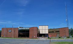
| Siedziba | North Haverhill | ||
| Kod statystyczny | FIPS 6-4: 33 009 | ||
| Powierzchnia | 4532,69 km²[1] | ||
| Populacja (2009) • liczba ludności |
| ||
Położenie na mapie New Hampshire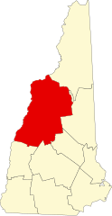 | |||
| 43°55′48″N 71°50′24″W/43,930000 -71,840000 | |||
| |||
| Strona internetowa | |||


Hrabstwo Grafton (ang. Grafton County) – hrabstwo w stanie New Hampshire w Stanach Zjednoczonych. Obszar całkowity hrabstwa obejmuje powierzchnię 1750,08 mil² (4532,69 km²). Według szacunków United States Census Bureau w roku 2009 miało 89 118 mieszkańców[2].
Hrabstwo powstało w 1769 roku[3].
Miasta
- Alexandria
- Ashland
- Bath
- Benton
- Bethlehem
- Bridgewater
- Bristol
- Campton
- Canaan
- Dorchester
- Easton
- Ellsworth
- Enfield
- Franconia
- Groton
- Hanover
- Haverhill
- Hebron
- Holderness
- Landaff
- Lincoln
- Lisbon
- Littleton
- Lebanon
- Lyman
- Lyme
- Monroe
- Orange
- Orford
- Piermont
- Plymouth
- Rumney
- Sugar Hill
- Thornton
- Warren
- Waterville Valley
- Wentworth
- Woodstock
CDP
- Ashland
- Bethlehem
- Bristol
- Canaan
- Enfield
- Hanover
- Lincoln
- Lisbon
- Littleton
- Mountain Lakes
- North Haverhill
- North Woodstock
- Plymouth
- Woodsville[4]
| Populacja hrabstwa w poprzednich latach[3] | |
|---|---|
| Rok | Liczba ludności |
| 1980 | 65 731 |
| 1990 | 74 929 |
| 2000 | 81 743 |
| 2005 | 84 708 |
Przypisy
- ↑ US Census Bureau: New Hampshire County. Population, Housing Units, Area, and Density: 2000. [dostęp 2011-07-17]. (ang.).
- ↑ a b US Census Bureau: Grafton County. Quickfacts. [dostęp 2011-07-17]. (ang.).
- ↑ a b National Association of Counties: Grafton County, NH. [dostęp 2011-07-17]. (ang.).
- ↑ National Association of Counties: Places in Grafton County, NH. [dostęp 2011-07-17]. (ang.).
- p
- d
- e

Kontrola autorytatywna (hrabstwo w stanie New Hampshire):
- Britannica: place/Grafton-county-New-Hampshire


