National Register of Historic Places listings in Crawford County, Georgia
This is a list of properties and districts in Crawford County, Georgia that are listed on the National Register of Historic Places (NRHP).
Map all coordinates using OpenStreetMap
Download coordinates as:
- KML
- GPX (all coordinates)
- GPX (primary coordinates)
- GPX (secondary coordinates)
This National Park Service list is complete through NPS recent listings posted June 14, 2024.[1]
- v
- t
- e
Properties on the National Register of Historic Places in Georgia by county
- Appling
- Atkinson
- Bacon
- Baker
- Baldwin
- Banks
- Barrow
- Bartow
- Ben Hill
- Berrien
- Bibb
- Bleckley
- Brantley
- Brooks
- Bryan
- Bulloch
- Burke
- Butts
- Calhoun
- Camden
- Candler
- Carroll
- Catoosa
- Charlton
- Chatham
- Chattahoochee
- Chattooga
- Cherokee
- Clarke
- Clay
- Clayton
- Clinch
- Cobb
- Coffee
- Colquitt
- Columbia
- Cook
- Coweta
- Crawford
- Crisp
- Dade
- Dawson
- Decatur
- DeKalb
- Dodge
- Dooly
- Dougherty
- Douglas
- Early
- Echols
- Effingham
- Elbert
- Emanuel
- Evans
- Fannin
- Fayette
- Floyd
- Forsyth
- Franklin
- Fulton
- Gilmer
- Glascock
- Glynn
- Gordon
- Grady
- Greene
- Gwinnett
- Habersham
- Hall
- Hancock
- Haralson
- Harris
- Hart
- Heard
- Henry
- Houston
- Irwin
- Jackson
- Jasper
- Jeff Davis
- Jefferson
- Jenkins
- Johnson
- Jones
- Lamar
- Lanier
- Laurens
- Lee
- Liberty
- Lincoln
- Long
- Lowndes
- Lumpkin
- Macon
- Madison
- Marion
- McDuffie
- McIntosh
- Meriwether
- Miller
- Mitchell
- Monroe
- Montgomery
- Morgan
- Murray
- Muscogee
- Newton
- Oconee
- Oglethorpe
- Paulding
- Peach
- Pickens
- Pierce
- Pike
- Polk
- Pulaski
- Putnam
- Quitman
- Rabun
- Randolph
- Richmond
- Rockdale
- Schley
- Screven
- Seminole
- Spalding
- Stephens
- Stewart
- Sumter
- Talbot
- Taliaferro
- Tattnall
- Taylor
- Telfair
- Terrell
- Thomas
- Tift
- Toombs
- Towns
- Treutlen
- Troup
- Turner
- Twiggs
- Union
- Upson
- Walker
- Walton
- Ware
- Warren
- Washington
- Wayne
- Webster
- Wheeler
- White
- Whitfield
- Wilcox
- Wilkes
- Wilkinson
- Worth

Current listings
| [2] | Name on the Register | Image | Date listed[3] | Location | City or town | Description |
|---|---|---|---|---|---|---|
| 1 | Crawford County Courthouse |  | September 18, 1980 (#80001008) | U.S. 80 32°43′28″N 83°59′53″W / 32.724444°N 83.998056°W / 32.724444; -83.998056 (Crawford County Courthouse) | Knoxville | |
| 2 | Crawford County Jail |  | May 18, 1989 (#89000418) | GA 42 32°43′27″N 83°59′44″W / 32.724167°N 83.995556°W / 32.724167; -83.995556 (Crawford County Jail) | Knoxville | |
| 3 | The Georgia Post Building |  | May 1, 2013 (#13000214) | 100 GA 42 S. 32°43′27″N 83°59′50″W / 32.72407°N 83.99713°W / 32.72407; -83.99713 (The Georgia Post Building) | Knoxville | |
| 4 | Col. Benjamin Hawkins Gravesite |  | November 10, 2011 (#11000790) | Benjamin Hawkins Rd. 32°40′01″N 84°05′44″W / 32.666944°N 84.095556°W / 32.666944; -84.095556 (Col. Benjamin Hawkins Gravesite) | Roberta | |
| 5 | Roberta Historic District | 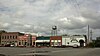 | May 19, 1989 (#89000365) | Roughly bounded by E. Cruselle St., Kirby St., Agency St., and Mather St. 32°43′07″N 84°00′40″W / 32.718611°N 84.011111°W / 32.718611; -84.011111 (Roberta Historic District) | Roberta | |
| 6 | Williams-Moore-Hillsman House |  | June 14, 2001 (#01000645) | West Hopewell Rd. at Colbert Rd, 32°45′44″N 84°07′35″W / 32.762222°N 84.126389°W / 32.762222; -84.126389 (Williams-Moore-Hillsman House) | Roberta |
References
- ^ National Park Service, United States Department of the Interior, "National Register of Historic Places: Weekly List Actions", retrieved June 14, 2024.
- ^ Numbers represent an alphabetical ordering by significant words. Various colorings, defined here, differentiate National Historic Landmarks and historic districts from other NRHP buildings, structures, sites or objects.
- ^ The eight-digit number below each date is the number assigned to each location in the National Register Information System database, which can be viewed by clicking the number.
Wikimedia Commons has media related to National Register of Historic Places in Crawford County, Georgia.


