National Register of Historic Places listings in Pulaski County, Georgia
This is a list of properties and districts in Pulaski County, Georgia that are listed on the National Register of Historic Places (NRHP).
Map all coordinates using OpenStreetMap
Download coordinates as:
- KML
- GPX (all coordinates)
- GPX (primary coordinates)
- GPX (secondary coordinates)
This National Park Service list is complete through NPS recent listings posted June 7, 2024.[1]
- v
- t
- e
Properties on the National Register of Historic Places in Georgia by county
- Appling
- Atkinson
- Bacon
- Baker
- Baldwin
- Banks
- Barrow
- Bartow
- Ben Hill
- Berrien
- Bibb
- Bleckley
- Brantley
- Brooks
- Bryan
- Bulloch
- Burke
- Butts
- Calhoun
- Camden
- Candler
- Carroll
- Catoosa
- Charlton
- Chatham
- Chattahoochee
- Chattooga
- Cherokee
- Clarke
- Clay
- Clayton
- Clinch
- Cobb
- Coffee
- Colquitt
- Columbia
- Cook
- Coweta
- Crawford
- Crisp
- Dade
- Dawson
- Decatur
- DeKalb
- Dodge
- Dooly
- Dougherty
- Douglas
- Early
- Echols
- Effingham
- Elbert
- Emanuel
- Evans
- Fannin
- Fayette
- Floyd
- Forsyth
- Franklin
- Fulton
- Gilmer
- Glascock
- Glynn
- Gordon
- Grady
- Greene
- Gwinnett
- Habersham
- Hall
- Hancock
- Haralson
- Harris
- Hart
- Heard
- Henry
- Houston
- Irwin
- Jackson
- Jasper
- Jeff Davis
- Jefferson
- Jenkins
- Johnson
- Jones
- Lamar
- Lanier
- Laurens
- Lee
- Liberty
- Lincoln
- Long
- Lowndes
- Lumpkin
- Macon
- Madison
- Marion
- McDuffie
- McIntosh
- Meriwether
- Miller
- Mitchell
- Monroe
- Montgomery
- Morgan
- Murray
- Muscogee
- Newton
- Oconee
- Oglethorpe
- Paulding
- Peach
- Pickens
- Pierce
- Pike
- Polk
- Pulaski
- Putnam
- Quitman
- Rabun
- Randolph
- Richmond
- Rockdale
- Schley
- Screven
- Seminole
- Spalding
- Stephens
- Stewart
- Sumter
- Talbot
- Taliaferro
- Tattnall
- Taylor
- Telfair
- Terrell
- Thomas
- Tift
- Toombs
- Towns
- Treutlen
- Troup
- Turner
- Twiggs
- Union
- Upson
- Walker
- Walton
- Ware
- Warren
- Washington
- Wayne
- Webster
- Wheeler
- White
- Whitfield
- Wilcox
- Wilkes
- Wilkinson
- Worth

Current listings
| [2] | Name on the Register | Image | Date listed[3] | Location | City or town | Description |
|---|---|---|---|---|---|---|
| 1 | Hawkinsville City Hall-Auditorium |  | March 1, 1973 (#73000638) | Lumpkin and Broad Sts. 32°16′56″N 83°28′08″W / 32.2823°N 83.4690°W / 32.2823; -83.4690 (Hawkinsville City Hall-Auditorium) | Hawkinsville | Built in 1907, now The Opera House |
| 2 | Hawkinsville Commercial and Industrial Historic District | 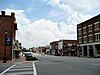 | December 13, 2004 (#04001349) | Roughly bounded by Dooly, Broad, Houston, and 3rd Sts. 32°17′04″N 83°28′01″W / 32.284444°N 83.466944°W / 32.284444; -83.466944 (Hawkinsville Commercial and Industrial Historic District) | Hawkinsville | |
| 3 | Hawkinsville Public School |  | May 28, 2008 (#08000492) | 215 Warren St. 32°16′43″N 83°28′25″W / 32.27869°N 83.47348°W / 32.27869; -83.47348 (Hawkinsville Public School) | Hawkinsville | 1936 (expanded in 1968) |
| 4 | Merritt-Ragan House |  | August 29, 1991 (#91001156) | 15 Merritt St. 32°16′44″N 83°28′04″W / 32.2788°N 83.4678°W / 32.2788; -83.4678 (Merritt-Ragan House) | Hawkinsville | |
| 5 | Pulaski County Courthouse |  | September 18, 1980 (#80001224) | Courthouse Sq. 32°16′59″N 83°28′08″W / 32.28295°N 83.46902°W / 32.28295; -83.46902 (Pulaski County Courthouse) | Hawkinsville | Built in 1874, is a contributing property to the Hawkinsville Commercial and Industrial Historic District |
| 6 | St. Thomas African Methodist Episcopal Church | 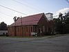 | December 7, 2000 (#00001477) | 401 N. Dooly St. 32°17′11″N 83°28′15″W / 32.28625°N 83.47082°W / 32.28625; -83.47082 (St. Thomas African Methodist Episcopal Church) | Hawkinsville | Built 1908-12 |
| 7 | Taylor Hall | 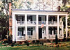 | November 17, 1978 (#78001000) | 504 Kibbee St. (55 Kibbee according to Chamber of Commerce publication) 32°16′32″N 83°28′18″W / 32.27545°N 83.47157°W / 32.27545; -83.47157 (Taylor Hall) | Hawkinsville | Built in 1825, is down a private drive with no view from public property |
| 8 | R. J. Taylor Memorial Hospital | Upload image | September 17, 2021 (#100006907) | 161 Commerce St. 32°17′01″N 83°28′20″W / 32.2835°N 83.4721°W / 32.2835; -83.4721 (R. J. Taylor Memorial Hospital) | Hawkinsville |
References
- ^ National Park Service, United States Department of the Interior, "National Register of Historic Places: Weekly List Actions", retrieved June 7, 2024.
- ^ Numbers represent an alphabetical ordering by significant words. Various colorings, defined here, differentiate National Historic Landmarks and historic districts from other NRHP buildings, structures, sites or objects.
- ^ The eight-digit number below each date is the number assigned to each location in the National Register Information System database, which can be viewed by clicking the number.
Wikimedia Commons has media related to National Register of Historic Places in Pulaski County, Georgia.
| |
|---|---|
| Topics | |
| Lists by state |
|
| Lists by insular areas | |
| Lists by associated state | |
| Other areas | |
| Related | |
| |


