National Register of Historic Places listings in Toombs County, Georgia
This is a list of properties and districts in Toombs County, Georgia that are listed on the National Register of Historic Places (NRHP).
Map all coordinates using OpenStreetMap
Download coordinates as:
- KML
- GPX (all coordinates)
- GPX (primary coordinates)
- GPX (secondary coordinates)
This National Park Service list is complete through NPS recent listings posted June 14, 2024.[1]
- v
- t
- e
Properties on the National Register of Historic Places in Georgia by county
- Appling
- Atkinson
- Bacon
- Baker
- Baldwin
- Banks
- Barrow
- Bartow
- Ben Hill
- Berrien
- Bibb
- Bleckley
- Brantley
- Brooks
- Bryan
- Bulloch
- Burke
- Butts
- Calhoun
- Camden
- Candler
- Carroll
- Catoosa
- Charlton
- Chatham
- Chattahoochee
- Chattooga
- Cherokee
- Clarke
- Clay
- Clayton
- Clinch
- Cobb
- Coffee
- Colquitt
- Columbia
- Cook
- Coweta
- Crawford
- Crisp
- Dade
- Dawson
- Decatur
- DeKalb
- Dodge
- Dooly
- Dougherty
- Douglas
- Early
- Echols
- Effingham
- Elbert
- Emanuel
- Evans
- Fannin
- Fayette
- Floyd
- Forsyth
- Franklin
- Fulton
- Gilmer
- Glascock
- Glynn
- Gordon
- Grady
- Greene
- Gwinnett
- Habersham
- Hall
- Hancock
- Haralson
- Harris
- Hart
- Heard
- Henry
- Houston
- Irwin
- Jackson
- Jasper
- Jeff Davis
- Jefferson
- Jenkins
- Johnson
- Jones
- Lamar
- Lanier
- Laurens
- Lee
- Liberty
- Lincoln
- Long
- Lowndes
- Lumpkin
- Macon
- Madison
- Marion
- McDuffie
- McIntosh
- Meriwether
- Miller
- Mitchell
- Monroe
- Montgomery
- Morgan
- Murray
- Muscogee
- Newton
- Oconee
- Oglethorpe
- Paulding
- Peach
- Pickens
- Pierce
- Pike
- Polk
- Pulaski
- Putnam
- Quitman
- Rabun
- Randolph
- Richmond
- Rockdale
- Schley
- Screven
- Seminole
- Spalding
- Stephens
- Stewart
- Sumter
- Talbot
- Taliaferro
- Tattnall
- Taylor
- Telfair
- Terrell
- Thomas
- Tift
- Toombs
- Towns
- Treutlen
- Troup
- Turner
- Twiggs
- Union
- Upson
- Walker
- Walton
- Ware
- Warren
- Washington
- Wayne
- Webster
- Wheeler
- White
- Whitfield
- Wilcox
- Wilkes
- Wilkinson
- Worth

Current listings
| [2] | Name on the Register | Image | Date listed[3] | Location | City or town | Description |
|---|---|---|---|---|---|---|
| 1 | Crawford W. Brazell House | 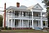 | June 17, 1982 (#82002486) | 607 Jackson St. 32°12′41″N 82°24′55″W / 32.21151°N 82.41533°W / 32.21151; -82.41533 (Crawford W. Brazell House) | Vidalia | Now the Altama Museum of Art & History |
| 2 | Citizens Bank of Vidalia |  | January 22, 1992 (#91002004) | 117 SE. Main St. 32°13′06″N 82°24′42″W / 32.218333°N 82.411667°W / 32.218333; -82.411667 (Citizens Bank of Vidalia) | Vidalia | Also part of the Vidalia Commercial Historic District |
| 3 | Robert and Missouri Garbutt House |  | December 28, 2000 (#00001564) | 700 W. Liberty St. (corner with Bulldog Rd.) 32°12′04″N 82°19′48″W / 32.20123°N 82.32997°W / 32.20123; -82.32997 (Robert and Missouri Garbutt House) | Lyons | |
| 4 | Leader-Rosansky House |  | June 20, 1995 (#95000735) | 403 Jackson St. 32°12′52″N 82°24′50″W / 32.21443°N 82.41377°W / 32.21443; -82.41377 (Leader-Rosansky House) | Vidalia | |
| 5 | Lyons Woman's Club House |  | May 2, 1985 (#85000940) | East Liberty St. 32°12′10″N 82°19′13″W / 32.20281°N 82.32040°W / 32.20281; -82.32040 (Lyons Woman's Club House) | Lyons | |
| 6 | McLemore-Sharpe Farmstead |  | August 19, 1982 (#82002487) | SW of Vidalia on GA 130 32°11′36″N 82°26′04″W / 32.1934°N 82.4345°W / 32.1934; -82.4345 (McLemore-Sharpe Farmstead) | Vidalia | |
| 7 | Peterson-Wilbanks House |  | March 22, 1990 (#90000491) | 404 Jackson St. 32°12′50″N 82°24′47″W / 32.21398°N 82.41317°W / 32.21398; -82.41317 (Peterson-Wilbanks House) | Vidalia | |
| 8 | Jim Smith House |  | August 31, 1989 (#89001213) | Rt. 3/Toombs County Rd. 18 32°01′03″N 82°15′09″W / 32.01745°N 82.25258°W / 32.01745; -82.25258 (Jim Smith House) | Lyons | |
| 9 | Vidalia Commercial Historic District | 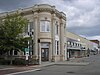 | September 27, 1996 (#96001020) | Roughly bounded by Meadow, Jackson, Pine, and Thompson Sts. 32°13′21″N 82°24′47″W / 32.2225°N 82.413056°W / 32.2225; -82.413056 (Vidalia Commercial Historic District) | Vidalia |
References
- ^ National Park Service, United States Department of the Interior, "National Register of Historic Places: Weekly List Actions", retrieved June 14, 2024.
- ^ Numbers represent an alphabetical ordering by significant words. Various colorings, defined here, differentiate National Historic Landmarks and historic districts from other NRHP buildings, structures, sites or objects.
- ^ The eight-digit number below each date is the number assigned to each location in the National Register Information System database, which can be viewed by clicking the number.
Wikimedia Commons has media related to National Register of Historic Places in Toombs County, Georgia.


