National Register of Historic Places listings in Twiggs County, Georgia
This is a list of properties and districts in Twiggs County, Georgia that are listed on the National Register of Historic Places (NRHP).
Map all coordinates using OpenStreetMap
Download coordinates as:
- KML
- GPX (all coordinates)
- GPX (primary coordinates)
- GPX (secondary coordinates)
This National Park Service list is complete through NPS recent listings posted June 7, 2024.[1]
- v
- t
- e
Properties on the National Register of Historic Places in Georgia by county
- Appling
- Atkinson
- Bacon
- Baker
- Baldwin
- Banks
- Barrow
- Bartow
- Ben Hill
- Berrien
- Bibb
- Bleckley
- Brantley
- Brooks
- Bryan
- Bulloch
- Burke
- Butts
- Calhoun
- Camden
- Candler
- Carroll
- Catoosa
- Charlton
- Chatham
- Chattahoochee
- Chattooga
- Cherokee
- Clarke
- Clay
- Clayton
- Clinch
- Cobb
- Coffee
- Colquitt
- Columbia
- Cook
- Coweta
- Crawford
- Crisp
- Dade
- Dawson
- Decatur
- DeKalb
- Dodge
- Dooly
- Dougherty
- Douglas
- Early
- Echols
- Effingham
- Elbert
- Emanuel
- Evans
- Fannin
- Fayette
- Floyd
- Forsyth
- Franklin
- Fulton
- Gilmer
- Glascock
- Glynn
- Gordon
- Grady
- Greene
- Gwinnett
- Habersham
- Hall
- Hancock
- Haralson
- Harris
- Hart
- Heard
- Henry
- Houston
- Irwin
- Jackson
- Jasper
- Jeff Davis
- Jefferson
- Jenkins
- Johnson
- Jones
- Lamar
- Lanier
- Laurens
- Lee
- Liberty
- Lincoln
- Long
- Lowndes
- Lumpkin
- Macon
- Madison
- Marion
- McDuffie
- McIntosh
- Meriwether
- Miller
- Mitchell
- Monroe
- Montgomery
- Morgan
- Murray
- Muscogee
- Newton
- Oconee
- Oglethorpe
- Paulding
- Peach
- Pickens
- Pierce
- Pike
- Polk
- Pulaski
- Putnam
- Quitman
- Rabun
- Randolph
- Richmond
- Rockdale
- Schley
- Screven
- Seminole
- Spalding
- Stephens
- Stewart
- Sumter
- Talbot
- Taliaferro
- Tattnall
- Taylor
- Telfair
- Terrell
- Thomas
- Tift
- Toombs
- Towns
- Treutlen
- Troup
- Turner
- Twiggs
- Union
- Upson
- Walker
- Walton
- Ware
- Warren
- Washington
- Wayne
- Webster
- Wheeler
- White
- Whitfield
- Wilcox
- Wilkes
- Wilkinson
- Worth

Current listings
| [2] | Name on the Register | Image | Date listed[3] | Location | City or town | Description |
|---|---|---|---|---|---|---|
| 1 | Bullard-Everett Farm Historic District | Upload image | January 15, 1998 (#97001648) | Address Restricted | Jeffersonville | |
| 2 | John Chapman Plantation | 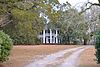 | August 11, 1982 (#82002491) | SE of Jeffersonville on GA 96 (address is 1286 as of 2017) 32°40′45″N 83°18′48″W / 32.67917°N 83.31332°W / 32.67917; -83.31332 (John Chapman Plantation) | Jeffersonville | |
| 3 | Myrick's Mill |  | December 6, 1975 (#75000613) | NE of Fitzpatrick on county road 378 32°47′02″N 83°22′05″W / 32.783889°N 83.368056°W / 32.783889; -83.368056 (Myrick's Mill) | Fitzpatrick | Historical marker at 32°47′41″N 83°22′21″W / 32.79483°N 83.37250°W / 32.79483; -83.37250 |
| 4 | The Pines |  | January 25, 2021 (#100006053) | 213 Shannon Dr. 32°41′06″N 83°20′45″W / 32.6851°N 83.3458°W / 32.6851; -83.3458 (The Pines) | Jeffersonville | |
| 5 | Richland Baptist Church |  | June 22, 1982 (#82002492) | Richland Rd. 32°37′50″N 83°24′02″W / 32.63052°N 83.40064°W / 32.63052; -83.40064 (Richland Baptist Church) | Jeffersonville | |
| 6 | Twiggs County Courthouse |  | September 18, 1980 (#80001248) | Courthouse Sq. 32°41′15″N 83°20′45″W / 32.6875°N 83.345833°W / 32.6875; -83.345833 (Twiggs County Courthouse) | Jeffersonville | Built 1902-04, later expanded (between 1980 and 2015) |
| 7 | Wimberly Plantation | 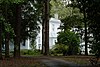 | June 17, 1982 (#82002493) | Jeffersonville Rd., GA 96 32°38′18″N 83°22′04″W / 32.63821°N 83.36767°W / 32.63821; -83.36767 (Wimberly Plantation) | Jeffersonville |
References
- ^ National Park Service, United States Department of the Interior, "National Register of Historic Places: Weekly List Actions", retrieved June 7, 2024.
- ^ Numbers represent an alphabetical ordering by significant words. Various colorings, defined here, differentiate National Historic Landmarks and historic districts from other NRHP buildings, structures, sites or objects.
- ^ The eight-digit number below each date is the number assigned to each location in the National Register Information System database, which can be viewed by clicking the number.
Wikimedia Commons has media related to National Register of Historic Places in Twiggs County, Georgia.
| |
|---|---|
| Topics | |
| Lists by state |
|
| Lists by insular areas | |
| Lists by associated state | |
| Other areas | |
| Related | |
| |


